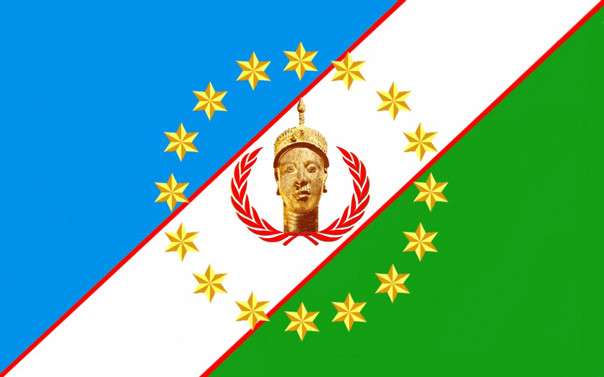
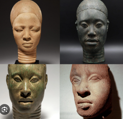
This blue, white and green design is used as a symbol of Yorùbá belonging, solidarity and the aspiration to self-determination. It brings a shared cultural identity into view across present-day borders and the diaspora.
It is a contemporary cultural and movement flag. Several Yorùbá flag designs circulate; this version is not presented as an ancient flag or the state flag of an internationally recognised sovereign country.
Read the colours and symbols
Blue, white and green
In the accompanying Commons account: sea; sky and peace; land.
Sixteen gold stars
Linked to traditions of sixteen founding lineages or settlements emerging from Ifẹ̀, and to illumination and progress. The number belongs to an origin tradition, not a count of modern states.
Red borders and wreath
Sacrifice and struggle; the wreath also evokes nobility.
The central head
A reference to shared origins, interpreted in the source as Odùduwà or Olókun. The emblem is not evidence that the sculpture is a verified portrait of either figure.
Listen to the original recording while exploring the words and masterpieces. Play, pause or seek in the YouTube player; the presentation follows its playback position.
Press play to begin.Connecting to YouTube…Connected · lyrics follow the player.YouTube is unavailable here. Open the original recording or browse the words and artwork below.
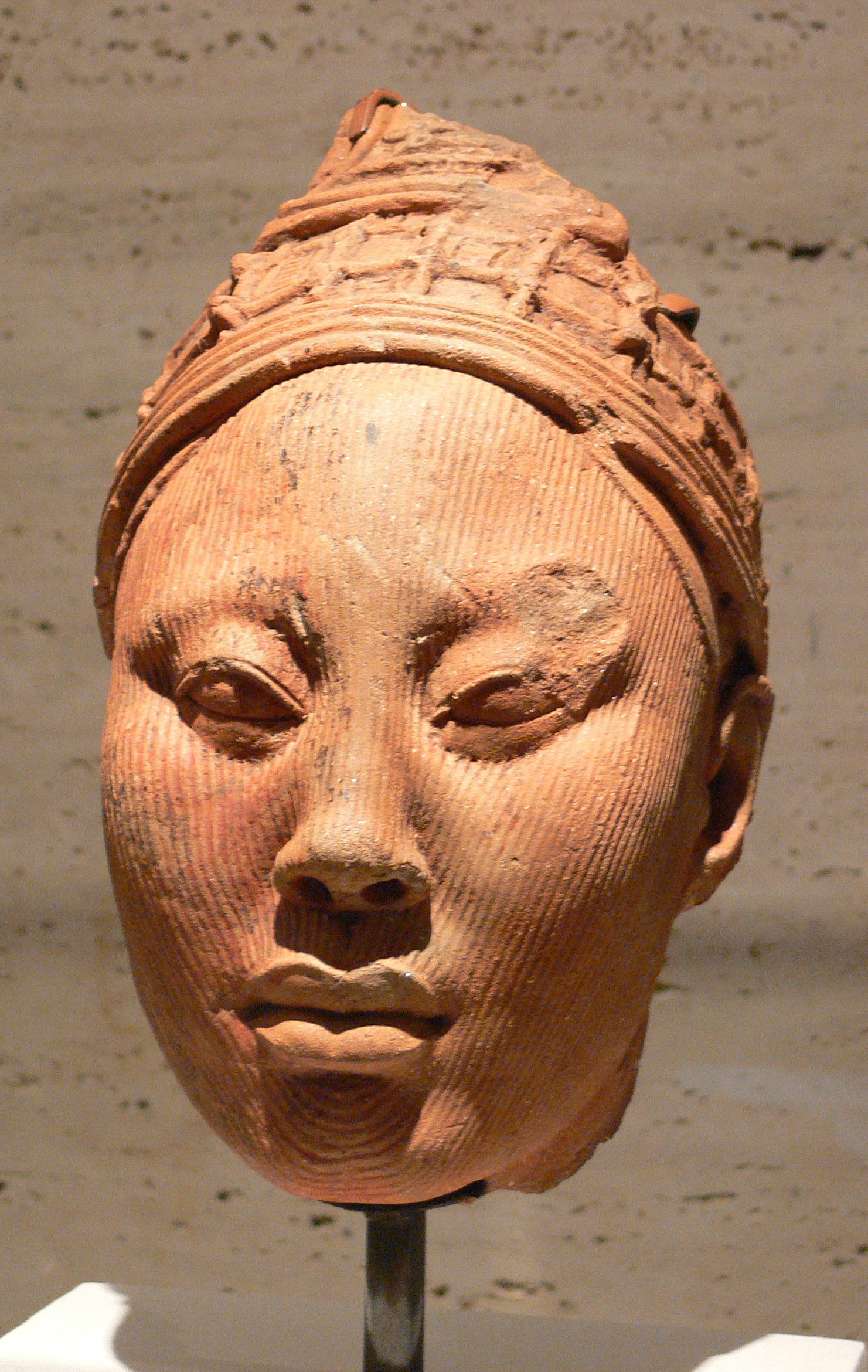
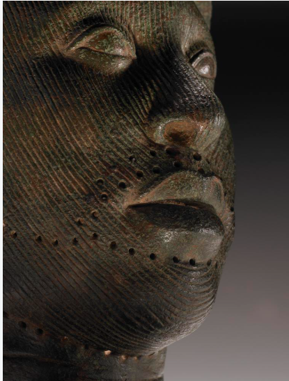
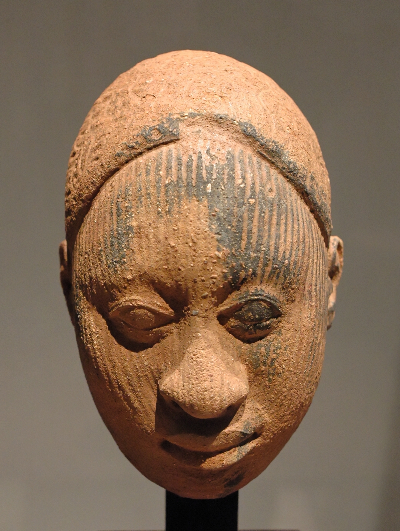
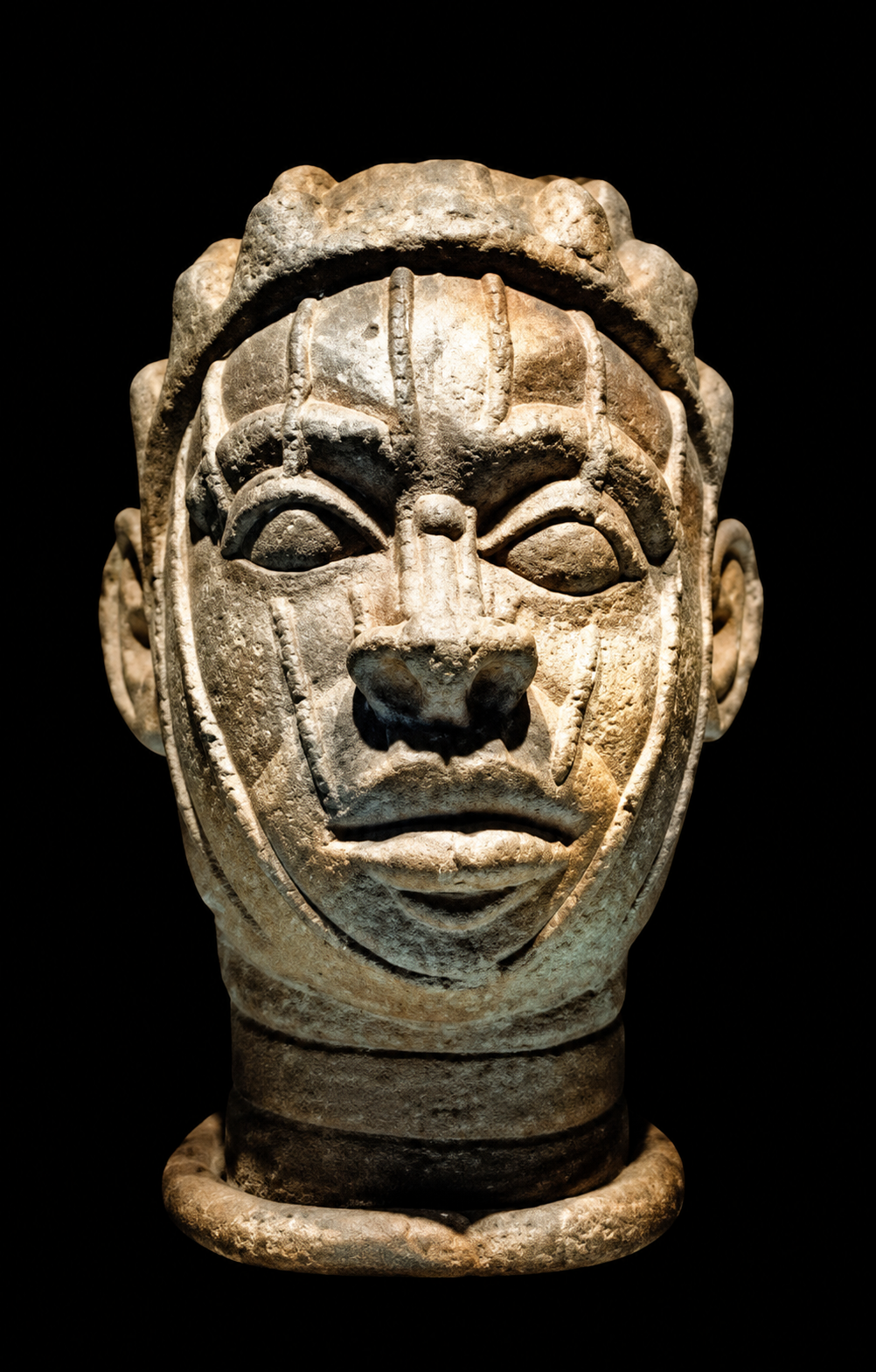
Terracotta · c. early 14th century · Blier’s attribution
Artwork and image credit
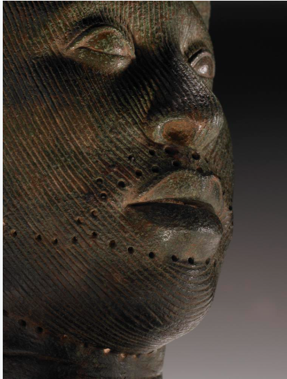
Broad marks fan out from the mouth towards the ears. Closed-looking eyelids and a firm mouth create a very different rhythm from the finely striated heads nearby. The catalogue describes “cat whisker” marks; no sitter is named.
Olókun Walode site · National Museums, Ifẹ̀, IF 67.1.5
Matched to Blier (2012), figure 18; photograph courtesy Hunterian Museum, University of Glasgow.
Approximate lyric timing · This recording has no timed caption track. The guide uses the quoted version below and may differ from the singing. Adjust the cues to match what you hear; English is an editorial rendering.
Adjust lyric timing
Times are seconds from the start of the recording. Set each line’s start time in ascending order, then apply. Your settings stay in this browser; they do not change the recording or other visitors’ settings.
Timing applied.Enter increasing times between 0 and the end of the recording.Timing applied for this visit. Browser storage is unavailable.
Choose a lyric line
Choose a line to jump to its cue. Without playback, this previews the words.
This anthem joins work for the homeland with dignity, shared prosperity, unity and liberty. The version below retains the “Ogo Adulawo” ending. Tone marks and underdots have been added to the quoted Yorùbá version; the facing English is an editorial rendering of its meaning, not a word-for-word transcript of the video.
Composition. In a 2021 account, Rauf Aregbesola credited Chief Obafemi Awolowo with writing the anthem in 1978 and Hubert Ogunde with adding its melody. This is the reported attribution for the anthem, rather than a production credit for this recording. Ripples Nigeria · 2021 ↗ · Osun Defender · 2024 ↗
Meaning. A call to serve Yorùbáland through work, shared dignity, unity, liberty and personal responsibility. Its closing appeal asks the children of Odùduwà to rise and embody the light and glory of Black people.
Yorùbá · quoted version
Iṣẹ́ wà fún ilẹ̀ wa Fún ilẹ̀ ìbí wa Ká gbé ga (×3) F’áyé rí
Ìgbàgbọ́ wa ni pé B’á ti b’ẹrú la b’ọmọ Ká ṣiṣẹ́ (×3) Ká j’ọlá
Ìṣọ̀kan àt’òmìnira Ni k’ẹ jẹ́ ká máa lépa Ìtẹ̀síwájú f’ọ̀pọ̀ ire Àt’ohun tó dára
Ọmọ Oòduà dìde Bọ̀ sí ipò ẹ̀tọ́ rẹ Ìwọ ni Ìmọ́lẹ̀ ogo Adúláwọ̀!
English · refined rendering
There is work to do for our homeland, For the land of our birth. Let us lift it high (×3), For the world to see.
We believe that The enslaved and the freeborn share the same human birth. Let us work hard (×3), And prosper together.
Unity and Liberty— Let these be our principal goal. Progressing perpetually towards greatness And all that is good.
Children of Oodua, arise; Take your rightful place. You are the unending light, The glory of Africa.
Reading the words and comparing versions
Work and shared prosperity
The work refrain calls for effort. “Prosper together” follows the communal reading made explicit in Osun’s published version. The contracted “Ká j’ọlá” can suggest enjoying wealth or honour, so the English is interpretive.
Equal human dignity
The comparison between enslaved and freeborn people challenges differences in social standing by pointing to their shared humanity. It does not endorse enslavement.
A rightful place
“Take your rightful place” follows the sense of “ipo eto re”: a call to dignity, responsibility and participation.
Progress, light and glory
The closing lines evoke progress, light and glory. Adúláwọ̀ refers to Black people; “Africa” is the broader poetic rendering retained in the title and closing line.
Two published endings
The Yoruba Action Council publishes the “Ogo Adulawo” ending. Osun State’s published text instead closes with “Gbogbo Adulawo”, addressing Black people collectively. These are variants, not one silently corrected lyric.
The quotation is the version presented for this page. The English is an editorial rendering; the selected performance may use a different lyric variant.
Follow two new maps from landscapes and mineral evidence to production, research and skills. Review 65 location records, compare places and follow sources into the development catalogue.
Yorùbá civilization did not begin with Nigeria. Its towns, kingdoms, languages, arts and systems of knowledge developed over centuries before the modern states of Nigeria, Benin and Togo. The division of connected Yorùbá and related Èdè-speaking communities between these countries is largely a legacy of European imperial expansion and colonial boundary-making. The map records that political history; it does not mark the natural limits of cultural belonging. The Berlin Conference of 1884–1885 helped establish the imperial framework; later conquest and boundary agreements produced the specific divisions. Berlin’s historical record.
Britain’s amalgamation on 1 January 1914 created a unified colonial Nigeria from its northern and southern administrations. This was an externally imposed political framework, not a union founded through the democratic consent of the peoples it joined. The name Nigeria was already in colonial use; 1914 joined administrations, not the beginnings of their peoples. Modern Nigerian citizenship can carry meanings people choose today, but it cannot make the much older Yorùbá inheritance a derivative of the state. Read the amalgamation documents.
Read the chronology: Berlin, colonial boundaries and 1914
1884–1885 · Berlin’s imperial framework
The Berlin Conference ran from 15 November 1884 to 26 February 1885, not 1886. No African representatives took part. It established rules through which the participating powers recognised colonial claims and intensified the partition of Africa. It did not draw every modern boundary at one sitting: specific borders emerged through subsequent agreements, surveys, occupation and conquest. German Foreign Office: the conference and General Act.
Late nineteenth century onwards · A cultural region divided
British expansion absorbed eastern Yorùbá territories into the colonial structures that became Nigeria; French rule placed western communities within Dahomey, now Benin. Other western communities came within German Togoland. After Germany’s defeat in the First World War, Togoland was divided between British and French administrations; present-day Togo emerged from the French-administered territory. These developments divided existing relationships between communities. They did not divide one previously unified Yorùbá nation-state: the region already contained different kingdoms, alliances and neighbouring peoples.
Under Governor-General Frederick Lugard, Britain joined Northern Nigeria and the Colony and Protectorate of Southern Nigeria. This administrative act did not create Yorùbá civilization, unite all Yorùbá communities, or settle the question of how the joined peoples wished to govern themselves. It was also distinct from the international boundaries separating British, French and German possessions. The colonial administration’s own 1914 report.
What should this inheritance mean now?
The dignity of Yorùbá civilization lies in what generations have created and carried forward; it was not bestowed by a colonial map. Taking that inheritance seriously calls for critical thought as well as pride. Which languages and knowledge will we teach our children? Which institutions deserve renewal or reform? How can communities cooperate across borders, care for their land and create prosperity? What forms of belonging, accountable government and peaceful self-determination should people be free to debate and choose?
Our past is a resource for shaping the future, not an instruction to repeat it. The task is to know it well enough to decide consciously what to preserve, what to challenge and what to build—with dignity for ourselves and respect for our neighbours.
Coloured dashes: modern country outlines, including coastlines
Loading the optional landscape index…
Drag to pan · pinch or use + / − to zoom · keyboard: arrows to pan, + / − to zoom, Home to reset. Tap a marker or choose a town above.
Yorùbá / related Èdè centresNeighbouring or shared contextNiger / Benue
Related communities cross present-day borders; they also have distinct histories and names. A town marker does not assign an identity to every resident. This atlas is selective and draws no fixed ethnic perimeter.
DISTANCE BETWEEN PLACES
Closer than the borders suggest?
Great-circle distance between approximate town points, not a road route, travel time or historic migration path.
Switch projections and compare Africa with Greenland. Equal Earth preserves relative areas; Mercator enlarges places farther from the equator.
GEOGRAPHIC AREA RATIO—
Africa compared with Greenland
APPARENT RATIO ON THIS MAP—
Calculated from the displayed outlines.
THE LESSONArea ≠ shape
Every flat world map makes compromises. Equal-area maps preserve size, not every distance, angle or outline shape.
On 4 September 2026, the UN General Assembly adopted resolution 80/307, “Correct the Map”, by 164 votes to 1, with 6 abstentions. It encourages more equitable cartographic representation. This is a change in how we see the world, not a change in borders. UN resolution record.
Natural Earth 1:110m generalized outlines. Africa includes Madagascar and the African island geometries present in this dataset; very small islands may be omitted. Antarctica is omitted from both displays. Mercator is clipped near the poles. Ratios are computed from the same features, not from screenshots.
COUNTRY SPOTLIGHT
Africa beside your choice.
The pink outline marks your choice. Geographic and displayed ratios use the same generalized geometries. Switch projections above to see what changes.
THE LATITUDE EFFECT
Move away from the equator.
The cyan parallel marks your chosen latitude. Mercator’s local area factor is 1 / cos²(latitude), relative to the equator; it is not the distortion of an entire country. USGS: map projections.
A SHARED SCALE / A DIFFERENT PERSPECTIVE
How much land are we looking at?
Compare the supplied Yorùbáland outline with countries across the world, or compare two countries directly. Search either list, choose a place, then drag the blue shape to overlap them. The whole UK and its four constituent nations remain available.
246 country, territory and regional comparison entries, grouped by continent. Type to filter; your current choice stays selected until you choose another.
The bronze silhouette follows the visible green outline in the supplied map, scaled to the area selected here. Its northern edge is cropped in the source image. Shape and area come from separate sources; this is an illustrative comparison, not a surveyed ethnic boundary.
Move blue outline:
Both shapes use the same kilometres-to-pixels scale. Moving or rotating the blue outline never changes its area. Country shapes use local Lambert azimuthal equal-area projections and spherical areas. UK nations use Natural Earth 1:10m subunits, with the whole UK formed from the same four shapes; other countries use 1:50m and Africa uses 1:110m. Numbers are approximate mapped areas, not cadastral or official land-area totals. Select the whole UK or any of its four constituent nations. Islands represented in the data are included; Crown Dependencies and overseas territories are excluded. “Metropolitan France” includes Corsica and excludes overseas territories; “France” includes the overseas areas represented in this dataset. The 246 entries include countries, territories and regional choices, not 246 sovereign states. Some dependencies are separate entries, and small islands may be omitted at this map scale. Natural Earth boundaries are generalized geographic references, not an endorsement of disputed claims.
COMPARISON COLLECTION
Put several places on one scale.
Keep up to four comparison places. The first area stays linked to your choice above. Bar length represents area, not a country’s width. Figures use the same mapped geometries as the outlines.
PEOPLE / AREA / POSSIBILITIES
What would that density mean?
A what-if calculation: the same population divided by each chosen area. These are not measured populations or actual country densities. 50 and 70 million are discussion scenarios, not equivalent census estimates. Read the population evidence.
ODÒ / ÒKÈ / IGBÓ / ÒKUN
Rivers, rock and the living landscape.
Follow the northern savanna and woodland through rocky uplands and southern forest zones to lagoons and the Atlantic coast. Explore Ìgbómìnà, Oró, Èdídí and the wider region.
Coloured dashes: modern country outlines, including coastlines
Drag or pinch to explore · + / − to zoom · arrow keys to pan · Home to reset. Search 101 towns, 50 featured landscapes and 614 additional physical places, or select a marker. Smaller features appear as you zoom; click any point for its name and source. Ctrl + wheel also zooms.
Solid blue: generalized Natural Earth rivers. Dashed blue: schematic smaller-river courses for orientation, not surveyed hydrography. Coloured diamonds: approximate landscape localities. Pale cyan: generalized Atlantic coastline. Small coloured points: gazetteer hills, water and forest localities. NASA Blue Marble is a historical satellite composite, not live imagery. Relief shows terrain, not rock type or a geological survey.
A LANDSCAPE WORTH KNOWING
Find a waterfall, a hill, a horizon.
Select a name to zoom to its locality and read its source. Names spread out as you zoom. These are landscapes lived in and cared for by communities, not empty sites awaiting development.
Read more: reservoirs, sacred hills and names worth checking
Water infrastructure is part of the living landscape: Ikere Gorge is in Oyo State, Egbe Reservoir is in Ekiti, and Erelu Reservoir serves Oyo town. Eko-Ende is a reservoir on the Otin River. The Ala River study concerns Akure; it should not be moved to Osogbo. Opa, Obudu and Esinmirin belong to the Ifẹ̀ catchment. These named waterways deserve closer hydrographic mapping; an uncertain course is not drawn as an exact line.
The expanded index connects reservoirs, creek systems, the OAU hills, Òkè Maria and Ọ̀yọ́-Ilé. Okomu is explicitly neighbouring Edo context. Zuma Rock, near Abuja, lies outside this regional atlas. Repeated names in the research notes have been merged. Vague entries such as “Rock of Gibraltar” in Osun, Ayorinde Lake, Apata Hill and an unspecified Olokun River need a precise locality and reliable source before receiving a pin. Local knowledge can help resolve these names.
Beautiful places are also working and sacred places. Their potential includes local guiding, research, conservation, water management and enterprises accountable to residents. Explore identity, productive capacity and a shared future.
ÒKUN / A COAST OF POSSIBILITIES
Ports, settlements and a living shoreline.
Trace the Atlantic coast, then move inland through lagoons and waterfront settlements. Èkó, Epe and the Ìlàjẹ waterways connect this story to Badagry, Àjàṣẹ́ / Porto-Novo and neighbouring Cotonou. These multilingual places have distinct histories; the regional coastline is not an ethnic boundary.
The development lenses are questions for exploration, not announced projects or site-suitability findings. Understanding who owns, uses and cares for each place comes before choosing what to build.
PLACES BEHIND THE MAP
See the landscape.
Real photographs, connected to places on the map. Choose a photograph or explore the collection in sequence.
IFẸ̀ BOWL / AN ARTISTIC INTERPRETATION
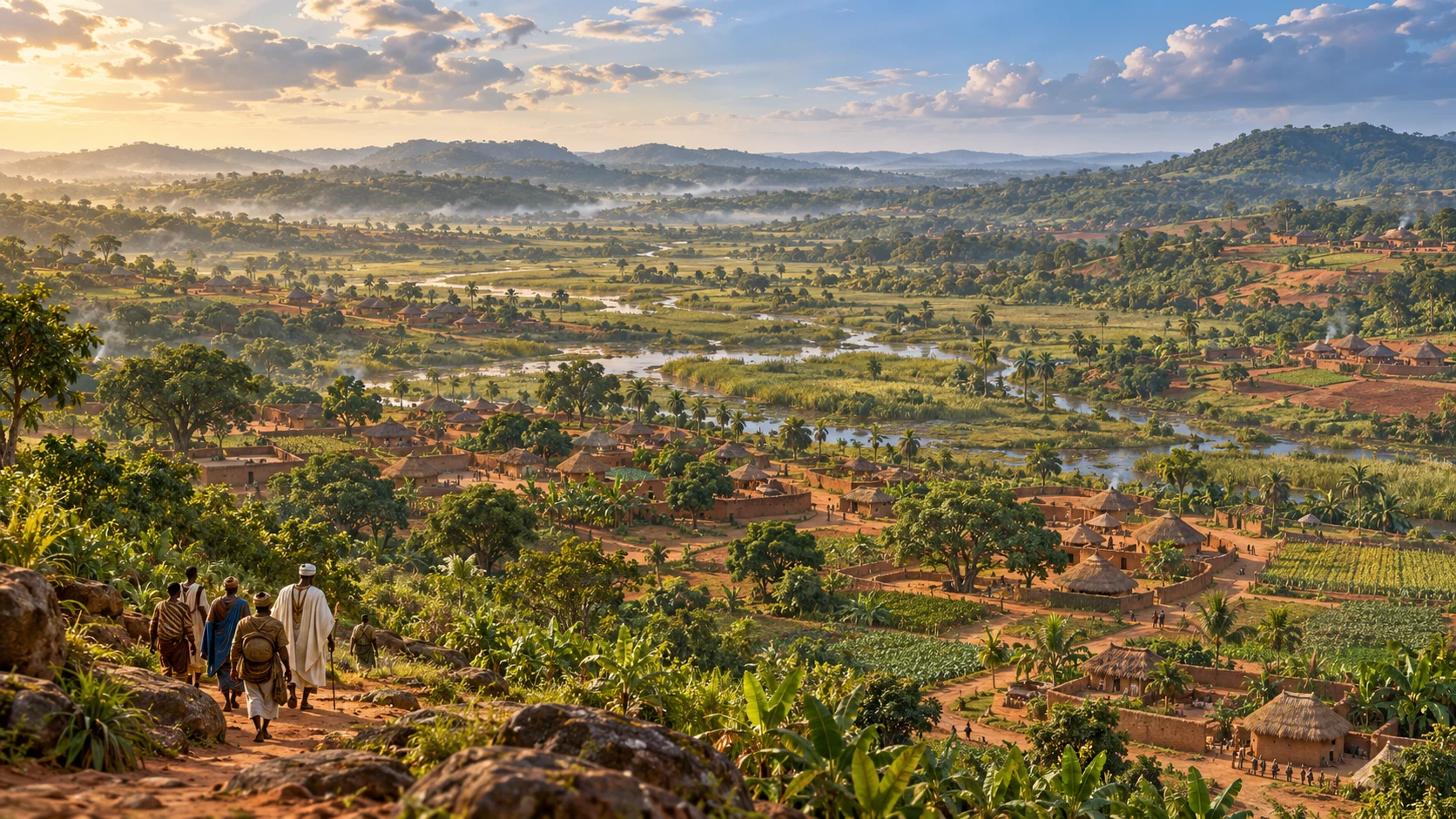
Before a city, an inhabited landscape.
Imagining Ilé-Ifẹ̀, broadly c. 900–1100 CE. AI-generated historical illustration in the Tapestries cinematic style. The travellers evoke an Odùduwà-associated arrival; they are not authenticated portraits. Buildings, clothing, vegetation and their arrangement are interpretive, not excavated reconstructions.
What does “Ifẹ̀ bowl” mean?
A basin framed by low hills, with streams, wetter ground and more easily cultivated slopes—not a volcanic crater. Akintoye describes a landscape of settlements already present before Odùduwà, with his pre-Odùduwà discussion centred on the ninth and tenth centuries. Akintoye, A History of the Yoruba People (2010), early Ifẹ̀ chapters.
When did power change?
No securely established arrival or accession year survives. Ogundiran places the conflicts associated with the Ọbàtálá and Odùduwà groups across the tenth and eleventh centuries. He describes earlier communities around the basin’s rim, movement into its drying floor, wall building and rivalry across generations, followed by accommodation within a centralised order. This is a longer transformation than one arrival and one takeover. Ogundiran, The Yorùbá: A New History (2020), ch. 2, pp. 52–69.
The date range frames this illustration; it does not date an individual lifetime. Sacred traditions and historical reconstructions offer different ways of understanding these figures.
Oramfe’s map and Ora Hill photograph
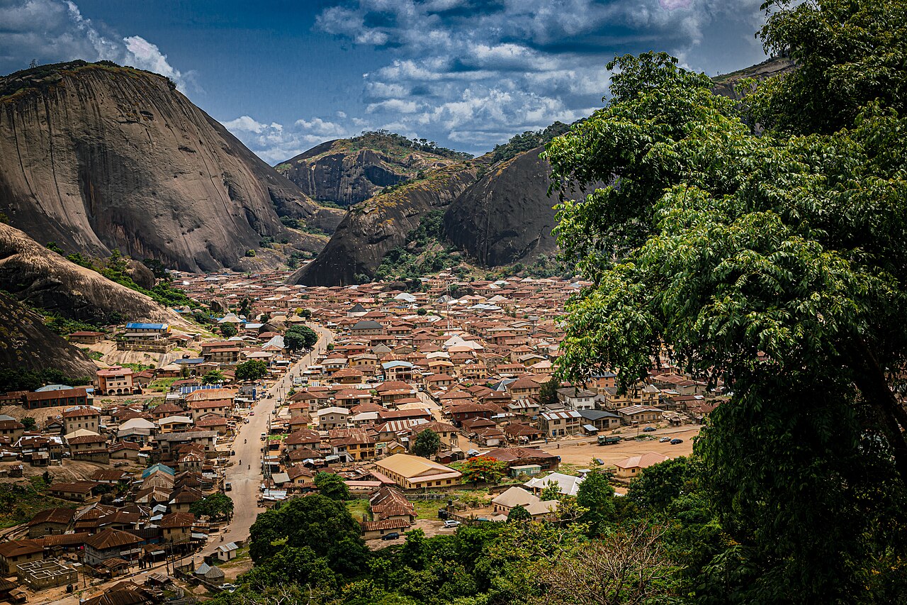
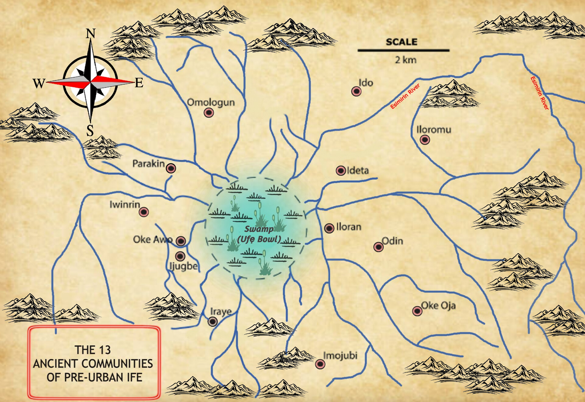
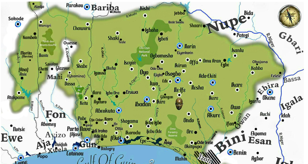
These two works by Oramfe bring different kinds of context to Ilé-Ifẹ̀: a modern map interpreting earlier communities, and a photograph of a hill in today’s landscape. Read them alongside the historical and archaeological sources in this chapter.
Thirteen communities around the Ifẹ̀ bowl
Oramfe’s map places thirteen named communities around the Ifẹ̀ bowl. Read it as an interpretation of estimated relative locations, not surveyed archaeological coordinates or a dated record of unification.
Original image reproduced without alteration. Select the image to view it at full size.
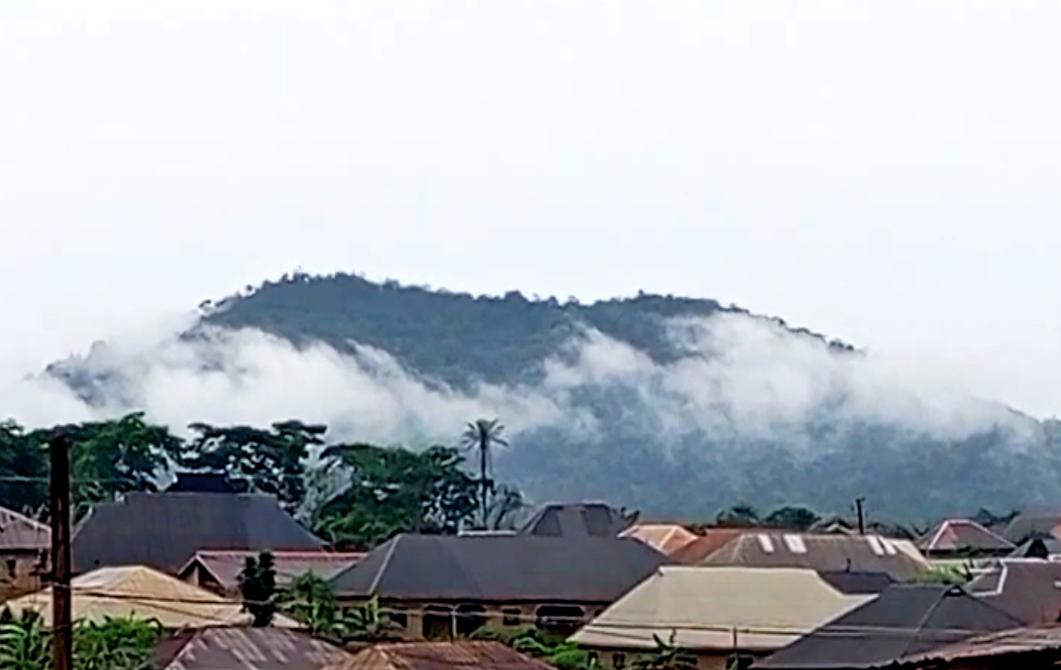
Ora Hill, looking east from Ifẹ̀
A present-day view of Ora Hill beyond the town’s rooftops. The photograph gives the landscape a tangible presence; it does not establish the route or date of an ancient migration.
Odò Ọya (River Niger) appears alongside local river names. Òkun means sea/ocean; here the coast meets the Gulf of Guinea, part of the Atlantic Ocean. Olókun is associated with the sea in Yorùbá religious traditions—not simply a geographic translation of “Atlantic”. Cultural context.
Read the landscape: ecology, scale and sources
Satellite landscape:NASA Blue Marble Next Generation, a 2004-era MODIS composite served by NASA GIBS. The colour image shows observed regional surface patterns; it is not a current land-cover survey and does not resolve streets or individual buildings. Satellite and terrain modes share the same geographic bounds. Ecological zones:RESOLVE Ecoregions 2017, CC BY 4.0, simplified and clipped to this regional window. This is an ecological framework, not a 2026 satellite land-cover assessment. The Guinean forest–savanna transition includes the northern Yorùbá landscape; the Dahomey Gap reaches the coast in Benin and Togo, interrupting the rainforest belt. Forest colour must not be read as uninterrupted deep forest: farms, towns, plantations and cleared areas occur within it.
Relief and rivers:Mapzen Terrain Tiles provide the detailed relief, sampled at roughly 300 metres with threefold vertical exaggeration for legibility. Elevation data include SRTM and GMTED courtesy USGS, and ETOPO1 courtesy NOAA; full attribution. It is not a hiking or geological survey. The 614 physical-place points come from GeoNames (CC BY 4.0), within this regional window in Nigeria, Benin and Togo. They include neighbouring landscapes and do not define Yorùbáland’s perimeter. Forest locality records do not establish current protection or tree cover. Solid river lines use Natural Earth 1:10m hydrography. Dashed courses are editorial sketches informed by the supplied reference and southwestern Nigerian basin research; they are deliberately distinguished from sourced line geometry. River names are given in local form where supported; unverified tone marks are not invented.
Places and interpretation: town points use the atlas’s GeoNames/family references. Landscape diamonds indicate approximate localities, not surveyed site entrances or reserve limits. The Usman–Falola geography chapter supports the broad landscape reading and Odò Ọya name; Ọ̀yọ́ State, Èkìtì State and UNESCO’s Omo account add local context. Each selectable landmark links to its source.
LAND / WATER / COORDINATES
Yorùbáland from above.
Explore satellite imagery across Nigeria, Benin and Togo. Find a town, inspect a coordinate, or locate yourself with your browser’s permission.
Coloured dashes: modern country outlines, including coastlines; country names appear on the map
Explore places & guided journeys
Choose a journey to follow its places.
Measure, share & take your own notes
Measure a sequence of straight-line segments. These are approximate geographic distances, not roads, walking directions or safe routes.
No measurement points yet.
Open this map to load satellite imagery.
Click the map to drop a coordinate pin, or turn on measuring to add successive points. Drag to pan; pinch or use + / − to zoom. Satellite imagery is not live: Blue Marble is a historical composite, while daily MODIS may show clouds or missing observations.
Select a point to find the five nearest places in the current category. Distances are straight-line estimates.
Select a place or click the map.
Follow coastlines, river corridors, uplands and broad settlement patterns. Markers connect the imagery to the atlas’s towns and physical places.
NASA imagery is regional: roughly 500 m for Blue Marble and 250 m for MODIS. Further zoom enlarges those pixels; it does not reveal street-level detail. The Google Maps link offers a separate, more detailed satellite view where available. GPS accuracy depends on your device. Your location is requested only when you press the button and is not saved by this site.
NASA GIBS imagery · Blue Marble context · GeoNames place points · Natural Earth river and border outlines. The map shows a regional window, not a fixed ethnic boundary.
ILẸ̀ / WHAT LIES BENEATH
Natural wealth. Informed choices.
Explore documented mineral localities across Yorùbáland and its neighbours. Follow the evidence from rock to possible use—and ask how that value could benefit the people who live here.
A curated mineral atlas, researched October 2026. Markers locate towns or study areas, not surveyed deposit boundaries. It includes selected mineral and hydrocarbon evidence, not a complete inventory of petroleum, water, soils or forests. An empty space means no entry yet, not no resources.
Drag to pan · pinch, + / − or Ctrl + wheel to zoom. Diamonds are locality anchors; squares indicate district inventories or an onshore reference for offshore resources. Outlined diamonds indicate neighbouring context. Marker size does not represent tonnage.
Questions for evaluation, not a project feasibility assessment. The opportunity prompt follows your selected resource entry.
FROM MATERIAL TO LIVELIHOOD
What could the value become?
These are questions for informed development, not an assessment that any specific project is viable.
READ THE EVIDENCE
A mineral is not yet a mine.
Occurrence: mineralisation has been observed. Resource: quantity and quality estimated under a stated reporting framework. Reserve: the economically mineable part after technical and other factors are assessed. Production: extraction reported for a stated period.
Geological studies and official promotional inventories do not automatically establish an economically recoverable reserve. This map does not add incompatible estimates together or assign a speculative monetary value to the land.
CLOSER TO HOME / ORÓ & ÌGBÓMÌNÀ
What does the evidence say here?
Oró now has its own entries. The official Irepodun inventory supports a district-level picture; the nearby Oreke–Owa-Kajola marble entries draw on sample testing. Square markers make broader inventories visibly different from locality records.
Read more about local reports and evidence
A 2023 geological paper mentions reported aquamarine around Oró, talc around Agbamu and minerals around Odo-Eku, but explicitly says these local reports were not documented. Their entries therefore carry “Reported · needs verification”. No economic reserve has been established by those reports.
Isanlu-Isin and Isanlu in Yagba are different places. Their evidence is kept separate. Knowing the land well means distinguishing a promising lead from a tested material and a viable project.
ONDO / TWO DIFFERENT RESOURCE STORIES
Coastal oil is not inland bitumen.
Yes: offshore Ondo extends into the western Niger Delta petroleum system. The 2017 Ororo field report records earlier oil and gas-condensate well tests. That is distinct from the natural bitumen studied around Agbabu.
Read more: fields, reserves and geography
Ororo is a named offshore field, not a name for all Ondo’s petroleum. Its historical report uses the category contingent resources: discovered hydrocarbons whose commercial development remains subject to conditions. This is not the same as proved reserves, and an old report does not establish present production.
OSOPADEC serves Ondo’s oil-producing and impacted areas in Ilaje and Ese-Odo. Political state boundaries and geological basin boundaries answer different questions. The map uses an explicitly labelled Igbokoda orientation square until a verified offshore field coordinate can be added.
Sources, geographic scope & what remains to be mapped
Entries draw on geological research, Benin’s Ministry of Water and Mines, JICA’s Togo corridor study, and dated operator reporting. Every entry links its own evidence. Coordinates generally use GeoNames settlement anchors (CC BY 4.0); the source link and precision note make the distinction from the actual deposit explicit. Natural Earth supplies the generalized country and river background.
Geology crosses cultural as well as political borders. Togo’s neighbouring stone localities are included for regional comparison, not labelled as exclusively Yorùbá. Turn neighbouring context off to hide those entries. Coverage is uneven: many northern communities, additional offshore fields and smaller quarries still need locality-level verification. District inventories use clearly identified square orientation markers; they are not converted into invented deposit locations. The Ororo entry uses an onshore Ilaje reference point, not an offshore well coordinate.
A long urban history, a living language, and communities whose connections reach across West Africa and the Atlantic. These facts are a starting point for curiosity—and for seeing the possibilities in the land and its people.
01 / PEOPLE & NUMBERS
A people across borders. A count with context.
Explore population by Nigerian state, homeland country and diaspora. The new ledger separates resident populations, identity and ancestry, with sources and an assumptions calculator.
About 51.5 million in the assembled numeric entries is an incomplete, mixed-source working estimate—not a census or the total of all Yorùbá-descended people. Brazil, Cuba, Haiti and missing modern communities remain unquantified.
Forced displacement through the Atlantic slave trade carried Yorùbá people and traditions to Brazil, Cuba, Haiti and beyond. Later migration created further communities in Britain, continental Europe, the United States and elsewhere. Within Africa, histories of movement connect the homeland with places including Ghana and Sierra Leone.
That wider ancestry is not captured by a language count. Nor does practising an Òrìṣà-derived religion establish a person’s ancestry: these are living, shared traditions with multiple African roots. Smithsonian: Yorùbá heritage abroad.
03 / ÈKÓ (LAGOS)
African megacity. Economic powerhouse.
Èkó is the largest contemporary urban centre in the Yorùbá cultural heartland and a profoundly cosmopolitan city, shaped by people from across Nigeria and beyond. Its commercial and creative reach makes it central to the region’s possibilities. This is my birthplace: a city whose creative confidence and entrepreneurial energy deserve to be celebrated. Meet Èkó (Lagos) and its royal communities ↗
Africa-wide superlatives need care. The UN’s 2025 urban comparison places Cairo ahead by population. Èkó (Lagos) State’s 2025 economic announcement reports a $259 billion economy at purchasing-power parity and ranks Èkó (Lagos) second among African city economies, behind Cairo. That is an attributed state-level estimate, not a like-for-like city GDP league table or a nominal-dollar figure.
04 / CITIES BEFORE COLONIAL BORDERS
Ilé-Ifẹ̀. Ọ̀yọ́. Ìbàdàn. Many centres.
Ilé-Ifẹ̀’s artistic and sacred importance, the power and networks of the Ọ̀yọ́ empire, and Ìbàdàn’s rise in the nineteenth century reveal a history of cities, markets, knowledge and changing political relationships. Yorùbáland was never simply one unchanging kingdom.
Imagine connected journeys through Ilé-Ifẹ̀, Ọ̀yọ́ and Ìbàdàn; the Ọ̀ṣun-Òṣogbo Sacred Grove; Abẹ́òkúta, Ìjẹ̀bú, the Èkìtì hills and Oǹdó; and onward to Kétu, Ṣábẹ̀, Ìdáàṣà and Ana-Ifẹ̀ across today’s borders. Old Ọ̀yọ́’s archaeological landscape is on Nigeria’s UNESCO Tentative List—not yet the World Heritage List.
Tourism already exists, sustained by communities, festivals, guides and cultural institutions. Its wider potential remains unevenly realised. Transport and visitor facilities, conservation funding, institutional coordination and consistent implementation all matter; research on Nigeria’s tourism planning describes political and administrative obstacles. UNESCO also records conservation and visitor-pressure challenges at Ọ̀ṣun-Òṣogbo. Growth must respect residents, sacred practices and the landscapes that make these places worth visiting.
This is part of why I built this website: to reconnect identity with place, make our histories easier to encounter, and invite a fuller appreciation of resource-rich lands and people—their knowledge, creativity, enterprise and capacity to shape their own future. My hope is for curiosity that leads to learning, visits, collaboration and opportunity on terms that benefit local communities.
A CULTURAL DIRECTORY
Places and people to know.
Follow a town, an art form or a name. Each is a doorway into a much larger story. Open a place below for a short introduction and a source.
Èkó (Lagos)My birthplace. A megacity with a worldwide voice.
Èkó (Lagos) is my birthplace, and a city I am proud to celebrate. Its restless creativity, commercial energy and ability to turn an idea into a livelihood give it a presence far beyond its shoreline. Music, film, fashion, art, finance, technology and maritime trade make it one of Africa’s great meeting places with the world.
The city’s achievements belong to its makers: market traders and entrepreneurs, artists and engineers, families rooted here for generations and people who have made it home. Its Yorùbá foundations and cosmopolitan life are both part of its strength. The question for the future is how that remarkable energy can produce more opportunity, better public space and a dignified life for everyone.
Scale needs a definition: the historic island, the built-up metropolis and the modern state cover different areas. The UN’s 2025 comparisons do not justify calling it Africa’s largest city under every measure. Its global significance needs no inflated ranking.
Read more · Kingdoms and royal communities across Èkó (Lagos) State
The metropolis and the modern state contain many older communities. Below is a selective directory of royal institutions, not a ranking or an exhaustive gazetteer. The five administrative divisions should not be mistaken for five kingdoms. Awori and Ìjẹ̀bú histories, Ogu heritage in Badagry, and other interconnected traditions deserve their own names and accounts.
Badagry’s Ogu-speaking heritage is integral to the state’s history; inclusion here does not relabel it as a Yorùbá kingdom. Epe’s two entries likewise preserve different community histories. Titles are listed without suggesting that every holder named in an older source remains in office. Historical research on Epe and Ikorodu ↗
ÌbàdànScholarship, literature and a historic metropolis
A major nineteenth-century city and a centre of intellectual life. University College Ibadan opened in 1948; today’s university carries that legacy of research, teaching and writing.
Ilé-Ifẹ̀Sacred kingship and extraordinary metalwork
A foundational centre in Yorùbá traditions of origin, associated with the Oòni and internationally celebrated copper-alloy and terracotta sculpture. Its artists’ technical achievement challenges old colonial assumptions about African art.
A key place in the movement and rebuilding of Ọ̀yọ́ political power: the Aláàfin established Ọ̀yọ́-Ìgbòho during the period of exile from the earlier capital. Robert Smith’s study examines that episode and its historical evidence.
Èṣìẹ̀ / EsieStone figures and Nigeria’s first national museum
In Ìgbómìnà country, a remarkable collection of carved stone human figures led to the establishment of a national museum in 1945. Archaeology and local accounts offer different ways of approaching the sculptures; the identities of their makers are not a settled fact.
Kétu · BeninGẹ̀lẹ̀dẹ́, performance and women’s authority
A major western Yorùbá centre associated with Gẹ̀lẹ̀dẹ́ masquerade arts. UNESCO recognises the wider Yoruba-Nago oral heritage across Benin, Nigeria and Togo, honouring women’s place in social and spiritual life.
Ṣábẹ̀ / Savè · BeninA kingdom with its own historical path
Ṣábẹ̀ belongs at the centre of a cross-border account of Yorùbá history. Research on the formation of its kingdom shows why local state-building histories cannot all be reduced to a single migration story from Ilé-Ifẹ̀.
A river-side place to explore connections between Yorùbá and Nupe worlds. The celebrated bronze bowman from Jebba belongs to the wider Middle Niger sculptural record; it should not be presented as proof that all Jebba heritage is exclusively Yorùbá.
Ọ̀yọ́-Ilé / Old Ọ̀yọ́An imperial capital written into the landscape
Surviving walls, palace remains, reservoirs and settlement traces reveal the scale of an earlier urban centre. This archaeological site is distinct from today’s Ọ̀yọ́ and is on Nigeria’s UNESCO Tentative List.
The Aláàfin’s city is a living cultural centre, not simply an echo of an empire. Its Ṣàngó festival brings together oral transmission, music, performance and devotion, recognised by UNESCO as intangible cultural heritage.
ÒṣogboSacred landscape and modern artistic renewal
The Ọ̀ṣun-Òṣogbo Sacred Grove connects forest, river, shrines, sculpture and continuing religious practice. Its twentieth-century artistic renewal sits within a much older sacred tradition; the grove remains a place of worship as well as a World Heritage site.
Ìlẹ̀ṣà / IlesaÌjẹ̀ṣà kingship, festival and regional journeys
The seat of the Ọwá Obòkun, known for the Ìwúdè festival and the memory of Ògèdèngbé. The wider Ìjẹ̀ṣà area offers the Olúmìrìn waterfalls at Erin-Ìjẹ̀ṣà and Kiriji-war heritage around Ìmẹ̀sì-Ilé—places near, rather than all inside, Ìlẹ̀ṣà.
A renowned centre of indigo resist-dyed cloth, and the setting for the women’s organising associated with Funmilayo Ransome-Kuti. Textiles and political history offer two distinct ways into the city’s story.
A major centre of narrow-strip weaving, where skilled makers keep aṣọ-òkè production alive through changing materials, designs and markets. Textile research documents its techniques and the knowledge of its weavers.
Royal arts illuminate exchange between Yorùbá Ọ̀wọ̀ and the Edo-speaking Kingdom of Benin. Those connections enriched local traditions without making the two places or peoples interchangeable.
Open a regional group, then a place. These are reading routes, not fixed political boundaries or a ranking of kingdoms. A town, a kingdom, a language community and a modern local-government area are different things.
Ìgbómìnà, Ìbọ̀lọ̀ and northern connections6 entries
Ìlá ÒràngúnKingship, language and learning
A major Ìgbómìnà centre associated with the Òràngún institution. Its place in Yorùbá history offers a way to connect royal traditions, community memory and the living Ìgbómìnà language.
Explore Òkè-Ìlá alongside Ìlá without merging the two towns. A recorded local oral history offers a community voice; the nearby Ayikunugba waterfall connects heritage with the upland landscape.
Yorùbá settlement and language, the emirate, Islamic scholarship and connections with Hausa, Fulani and other communities all belong in the city’s story. Historical writing about Ìlọrin requires attention to whose account survives.
A major town in today’s Kwara and an important doorway into the Ìbọ̀lọ̀ region. Explore its community institutions and connections with neighbouring towns alongside the wider histories of northern Yorùbáland.
Ọ̀bà-Isin / Ọ̀bà ÌgbómìnàSettlement memory in Isin
A historic Ìgbómìnà town in Isin. Local accounts of Ọ̀bà deserve to be read alongside the archaeology of the wider region; broad regional evidence does not establish every detail of a town’s origin tradition.
Òmu-Aran, Ìgbàjá and Isin communitiesBeyond a single royal centre
Follow the settlements around Òmu-Aran, Ìgbàjá, Ìjàrà-Isin, Òwù-Isin and Èdídí. Aribidesi Usman’s regional research offers a route into settlement, material culture and the stone-sculpture record.
Ire · Ilupeju · Itapa · IjeluSmaller centres, living knowledge
Include Ire, Ilupeju, Itapa, Ijelu, Ayegbaju and Ilemeso when exploring the Oye area. Towns, villages and royal institutions do not map neatly onto the same categories.
Oǹdó kingdom is a particular historical community; modern Ondo State contains several other kingdoms and cultural regions. Begin with this distinction when exploring its political and cultural history.
A historic royal centre as well as the modern state capital. Its urban story belongs alongside, rather than inside, the separate history of Oǹdó kingdom.
The historic hill settlement combines architecture, sacred places and a striking physical setting. Read the site’s heritage record alongside the photographs and landscape map.
Explore Àkókó through its many towns and local institutions. These centres open a window onto the linguistic and political variety of the northeastern part of today’s Ondo State.
Ìkálẹ̀ and Ìlàjẹ centresOde-Okitipupa · Ode-Irele · Igbokoda
Move from inland settlements towards the waterways. These regional identities and local kingdoms need their own accounts; a modern state name should not flatten them into a single origin story.
An important royal and trading centre within a much wider Ìjẹ̀bú landscape. The surrounding towns are communities in their own right, not simply neighbourhoods of Ìjẹ̀bú-Òde.
Ìjẹ̀bú-Igbó and Ago-IwoyeNorthern Ìjẹ̀bú connections
Include both towns when following the settlement network beyond Ìjẹ̀bú-Òde. Their community histories add different perspectives to the regional picture.
The shared Ìjẹ̀bú name carries connections without making these places interchangeable. Explore local accounts of institutions, settlement and belonging.
Local documentation names a network of communities, including Odonopa, Iwasi, Imeri and Imuwen. This finer scale makes room for histories that disappear when a map shows only major towns.
Odogbolu · Ijebu-Itele · Ijebu-IsiwoMore doorways into Ìjẹ̀bú
A starting set for exploring local markets, family accounts and town institutions. Read each community’s history on its own terms within the wider region.
Ṣagamu, Ikenne, Iperu and IsaraRẹ́mọ’s connected towns
Rẹ́mọ has its own local identities and royal histories, connected with the wider Ìjẹ̀bú world. Include Ilisan, Ode-Remo and Akaka in a fuller exploration.
Mopa · Amuro · Ife-OlukotunMore of Yagba’s settlement network
Follow Mopa and the Amuro communities alongside Ife-Olukotun, Ejuku and Ponyan. These are starting points for local histories, not a claim that every Okun community has an identical origin.
Historic Ọ̀yọ́ towns and regional connections3 entries
Ògbómọ̀ṣọ́The Soun’s city
A major historical centre in the wider Ọ̀yọ́ world. Its own institutions and urban history complement the separate stories of Old Ọ̀yọ́, Ìgbòho and today’s Ọ̀yọ́.
Ṣakí · Kìṣì · Ìgbètì · ÒkèhoThe northern and western town network
Follow these towns alongside Ṣẹpẹtẹrí and Ilero to appreciate a connected region beyond the imperial capital. Markets, landscapes and community institutions offer different entry points.
Yewa / Ẹ̀gbádò and neighbouring borderland communities3 entries
Ilaro · AyetoroCentres of the Yewa region
Yewa, historically also called Ẹ̀gbádò, belongs in any account of western Yorùbáland. These centres connect the directory to communities approaching today’s Benin border.
Imeko · Afon · IwoyeBorderland towns and relationships
Explore local languages, trade and family connections across the western borderlands. Administrative lines do not capture all the relationships between these communities.
Ipokia · Idiroko · Ado-Odo and neighboursA multilingual borderland
The wider area includes Yewa, Awori and Ogu/Egun communities. These names should be retained rather than treating every settlement in Ogun West as one homogeneous kingdom.
One of the principal centres of the Abẹ́òkúta story. The palace and its museum provide a way into local institutions, civic history and historical collections.
A distinct royal community within the wider Ẹ̀gbá landscape. Its story deserves attention alongside Aké rather than being hidden behind a single city label.
One of the communities that shaped Abẹ́òkúta. Read its own account of movement and settlement alongside the wider history of nineteenth-century change.
Òwu has its own historical identity and became part of Abẹ́òkúta’s shared urban story. Connection with Ẹ̀gbá communities does not erase that distinctiveness.
Two towns that extend the directory through southeastern Benin. Explore their communities within a multilingual setting, rather than assigning every resident one identity.
Togo · Ana-Ifẹ̀ and Northern Nago connections4 entries
AtakpaméAn Ana-Ifẹ̀ centre in a multilingual city
Explore Ifè language, local memory and the city’s hill landscape. Ana-Ifẹ̀ is a living western language tradition, not merely a distant footnote to Nigerian history.
A further centre in the wider Ana-Ifẹ̀ region. Local language and settlement histories make this landscape more varied than a map with only one western marker suggests.
Datcha, Kamina and the wider Ifè-speaking areaMore names to follow
Further settlements in the Ifè-speaking geography of Togo. These names are included as starting points for local exploration; the directory does not draw a fixed ethnic perimeter.
Look at the patient modelling of a mouth, the rhythm of a crown, the assurance of a seated body. Ifẹ̀’s artists gave form to a society with demanding patrons, specialised knowledge and a powerful visual imagination. For me, these works express a civilization confident in its own value. That is a response to the art—not proof that we know every sitter’s identity or thoughts.
Three works begin the gallery. Open the collection below for seventeen more works, detail views and research references. Select a photograph to look closer; open its record for dating, location and credit.
14th–early 15th century British Museum · Af1939,34.1
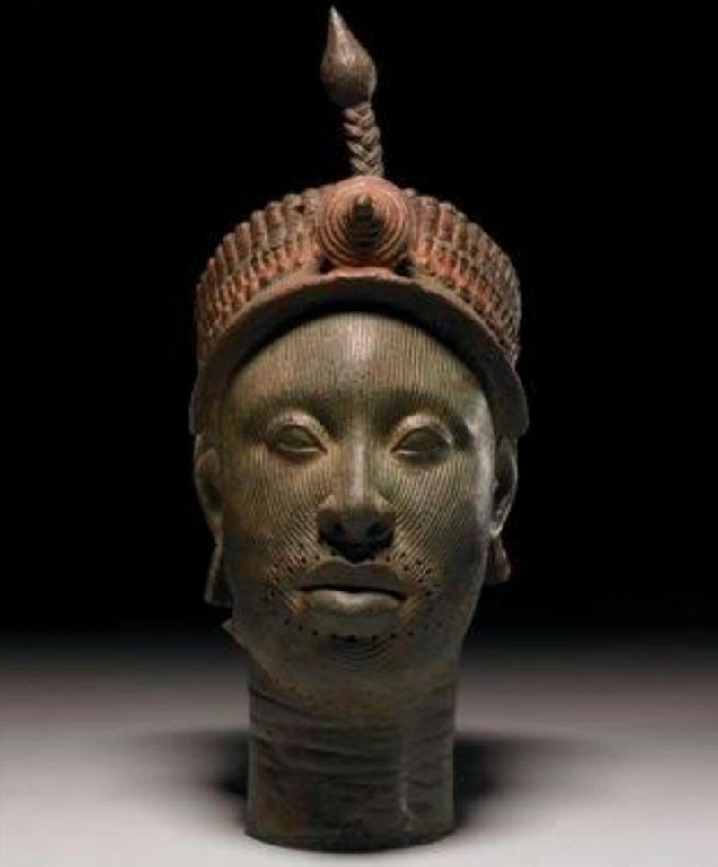
The composed mouth, steady gaze and elaborate crown invite a reading of authority held with assurance. The museum identifies a probable ruler; a particular monarch’s name is not established. This is the Ifẹ̀ head—not a verified portrait of Odùduwà.
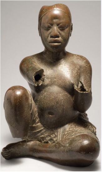
The seated body makes physical presence its subject. Found at Tada beside the Niger, and attributed to Ifẹ̀, it connects sculptural skill with river routes and ritual life. Its surviving form commands attention without requiring us to invent the sitter’s name.
12th–14th century Kimbell Art Museum, Fort Worth · AP 1994.04
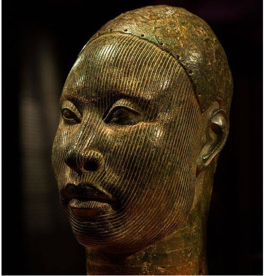
A fine network of lines follows the face beneath an intricate crown. The title “Head, possibly a King” preserves an important uncertainty. The quiet expression and exact modelling reward slow looking: royal dignity is suggested, rather than shouted.
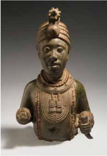
c. early 14th century · Blier’s attribution National Museums, Èkó (Lagos) · 38.1.1, as catalogued in 2012
Layered beads, a rosette-topped crown and poised hands give this surviving upper body its ceremonial presence. It is catalogued as a king; neither the photograph nor the record securely identifies a particular ruler.
c. early 14th century · Blier’s attribution National Museums, Ifẹ̀ · head no. 6 in Blier, figure 20
Fine facial lines turn across cheeks and brow, while the surviving surface records age and damage. The image corresponds to the striated head illustrated in Blier’s study. We can admire the maker’s precision without claiming to know the subject’s thoughts.
12th–14th century · image catalogue Photographed at the Louvre · A96-1-4 / 73.1996.1.4
The lips, eyelids and facial lines are individually articulated in fired clay. The image catalogue suggests a court attendant rather than a king. Ifẹ̀’s achievement includes a wider human world, not only monarchs.
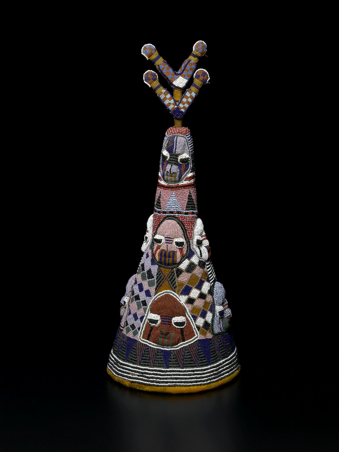
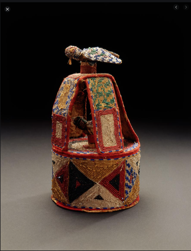
Exact date unverified; not assigned a medieval date Maker and present collection not confirmed
Faces, birds and patterned beadwork extend the conversation into Yorùbá royal regalia. The linked Met account explains comparable crown traditions; it does not identify this particular crown. Living craft deserves attention alongside archaeological masterpieces.
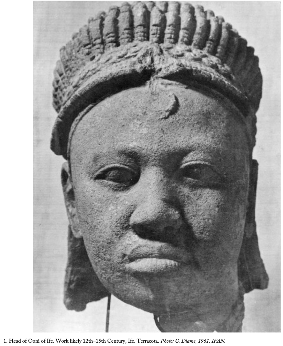
12th–15th century · image caption Ilé-Ifẹ̀ · individual ruler not identified
A crescent-like forehead ornament sits beneath a substantial crown. Full lips and attentive eyes give the face a composed presence. The original caption calls this a head of an Oòni; it does not establish which ruler is represented.
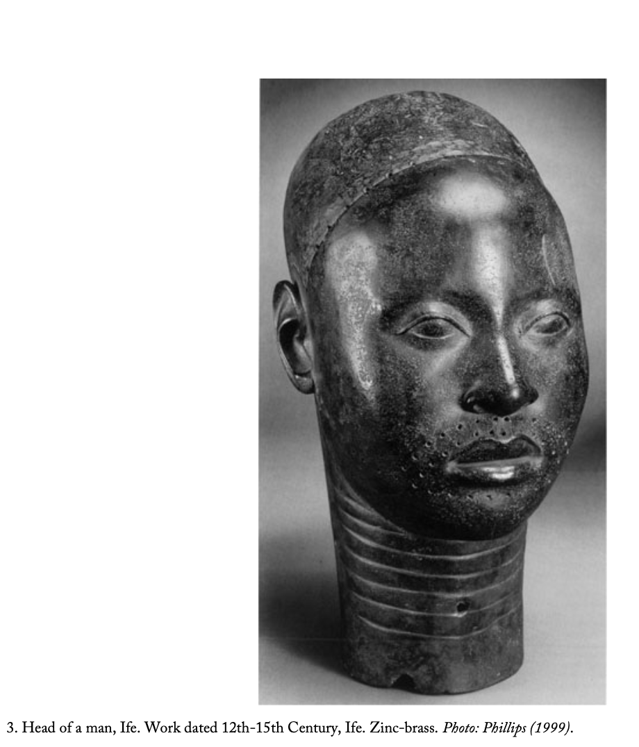
12th–15th century · image caption Ilé-Ifẹ̀ · sitter unnamed
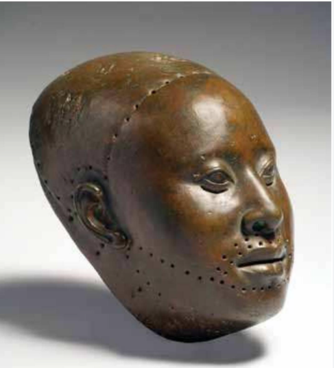
Smooth cheeks contrast with the texture of the cap and the rings around the neck. Small holes surround the mouth. The published caption identifies a man, not a named monarch; that distinction is retained here.
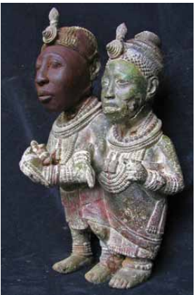
c. early 14th century · Blier’s attribution National Museums, Ifẹ̀ · 57.1.1
Interlocked arms and feet bind two crowned figures together. Necklaces, patterned garments and objects held in the hands make their relationship and ceremonial presence visible. Their individual names are not established.
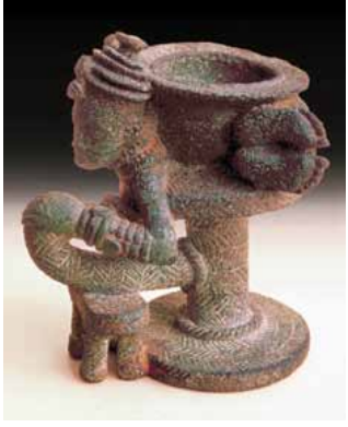
c. early 14th century · Blier’s attribution Ìta Yemoo · National Museums, Èkó (Lagos), L.92.58
A crowned figure curves around the vessel, with a small staff and looping throne below. Blier describes a recumbent queen. The intimate scale rewards looking at the connections between body, seat and bowl.
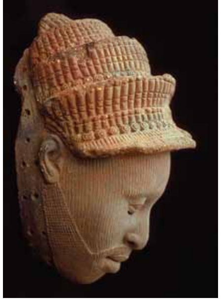
c. early 14th century · Blier’s attribution Ọbàfẹ́mi Awólọ́wọ̀ University · excavation OC2
A tiered headdress rises above closely spaced facial lines. The profile reveals the precision of the nose, lips and projecting brim. This is catalogued as a mask from the Ọbalúfọ́n temple site, not a securely named individual.
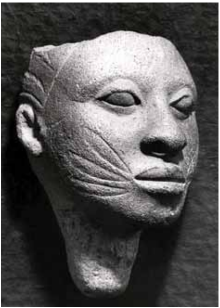
c. early 14th century · Blier’s attribution Olókun Walode site · National Museums, Ifẹ̀, IF 67.1.5
Broad marks fan out from the mouth towards the ears. Closed-looking eyelids and a firm mouth create a very different rhythm from the finely striated heads nearby. The catalogue describes “cat whisker” marks; no sitter is named.
Object-specific date unverified Maker, collection and accession not established
Broad facial markings, pronounced eyes and a firm mouth make this head a striking study in sculptural expression. It is retained as an identification reference: the photograph does not establish its material, archaeological context or a named sitter.
Object-specific date unverified Detail view · exact catalogue match unverified
Close-set facial lines curve around the cheeks while rows of holes frame the mouth and chin. This view rewards attention to the maker’s precision and the surviving surface. Those features alone cannot identify the sitter or establish the purpose of every perforation.
Object-specific date unverified Probable ilé orí · maker and collection unverified
A bead-covered bird crowns an open structure of bright panels and geometric patterns. Its form is consistent with an ilé orí, a shrine associated with the inner head and personal destiny. This is a provisional identification, not a royal crown attribution or a medieval date.
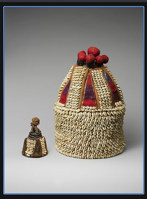
Cowrie shells, cotton, leather and mixed-media offerings
Orí: a shrine and its inner presence.
19th–20th century The Metropolitan Museum of Art · 1978.412.459a–c
The small ìbọrí stands beside its larger house, making the relationship between inner presence and protective enclosure visible. The Met describes the shrine as a way of tending the orí inú, or inner head. Dense cowrie rows give material expression to care, value and personal destiny.
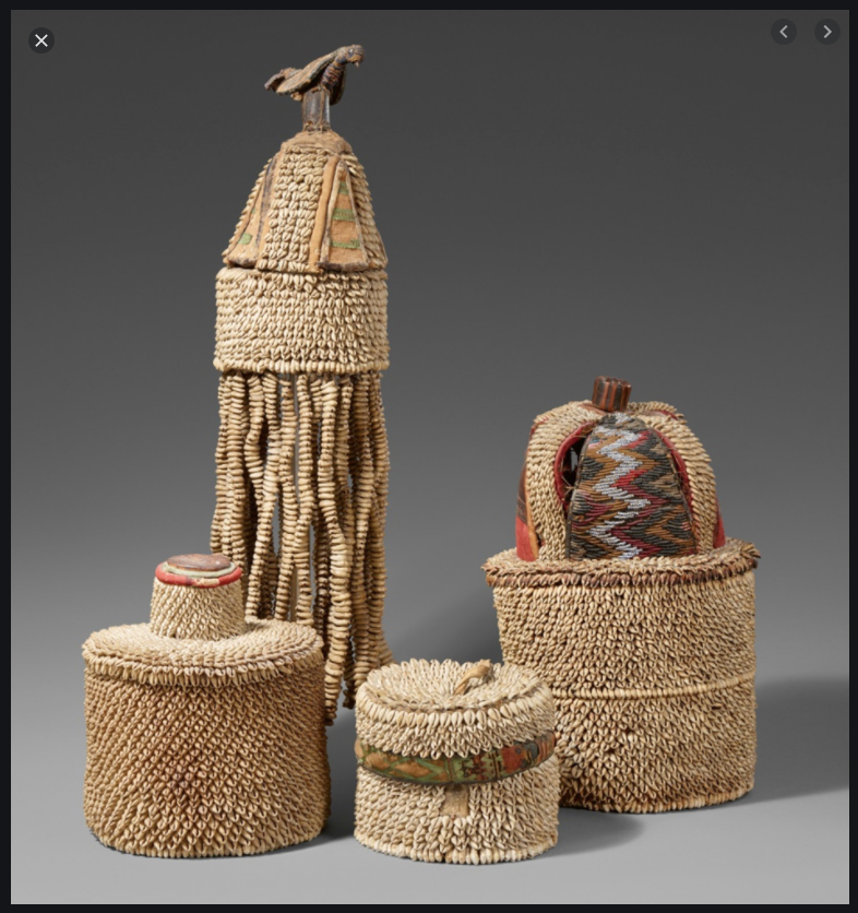
Cowrie-covered shrines · materials not fully catalogued
Four houses. Individual destinies.
Manufacture dates unverified · auction record 2019 Lempertz · auction 1129, lot 310 · Nigeria
Four ilé orí show different ways of building a sacred enclosure: a tall bird finial, cascading strands, compact cylinders and patterned panels. The auction catalogue records heights of 19–49 cm. The bird-topped example was exhibited in Bamberg in 1991; that is an exhibition date, not its date of manufacture.
Read more · How old are these works—and how do we know?
Earlier than Michelangelo and Raphael.
The Kimbell head’s published 12th–14th-century range and the British Museum head’s 14th–early 15th-century range precede the lifetimes of Michelangelo (1475–1564) and Raphael (1483–1520). They therefore predate those artists’ work. This is a chronological comparison, not a claim that every Ifẹ̀ object predates the entire European Renaissance. Ifẹ̀ deserves to be understood in its own intellectual and artistic setting.
A date range is not automatically a carbon date. Radiocarbon dates organic material; it does not directly date a brass head. Archaeological layers and associated organic remains can help establish context. Thermoluminescence can investigate fired clay, including surviving casting cores. Museum attributions may combine scientific results, excavation evidence and stylistic comparison. The caption states the published range or scholarly attribution; no individual laboratory test is claimed without a record. Smithsonian: thermoluminescence dating of Ifẹ̀ and Benin casting cores ↗
A BBC CASE STUDY / 26 JUNE 2022
A masterpiece is more than a market price.
Barnaby Phillips’s BBC report: “Nigerian Ife head: Why UK police are holding a priceless sculpture” ↗ follows a head stolen from Jos Museum in 1987 and handed to London police in 2017. In the 2022 account, competing ownership claims obstructed its return. An auction specialist’s £20 million valuation was hypothetical—not a sale price. The loss concerns knowledge, belonging and access as much as money.
This is the position reported in June 2022, not a claim about present police custody. The BBC text was checked through its attributed republication. It concerns a specific museum theft, distinct from nineteenth-century colonial seizure.
Read more · Where the works are, and why return matters
A dispersed inheritance, with important collections at home.
Many major Ifẹ̀ works remain in Nigerian collections. The 2010 British Museum exhibition review records 109 loans from Nigeria’s National Commission for Museums and Monuments and two works from the British Museum’s own nine Ifẹ̀ objects. An exhibition photograph in London does not prove British ownership: some collection records are of modern casts of Nigerian originals.
Original works also appear in collections in London, Paris, Berlin and the United States. The Kimbell catalogue lists its head on view; other objects move between galleries, loans and storage. There is no verified basis here for saying that most Ifẹ̀ masterpieces lie in British Museum vaults. Museum location, legal title, acquisition history and present display are separate questions.
Return, with dignity and accountable care.
My position is clear: African heritage wrongfully taken should be returned to its rightful owners and communities. Transparent provenance research, meaningful involvement of source communities, conservation funding and accessible museums can make restitution a lasting act of repair. International scholarship and agreed loans can continue on equitable terms. Different objects have different histories: Ifẹ̀, Benin and other African collections must not be collapsed into a single account of looting. The British Museum’s account of the 1897 Benin seizure gives a distinct colonial example; UNESCO’s account of a different Ifẹ̀ terracotta returned in 2020 shows that return can happen.
Consider a reversal: if the Crown Jewels and historic suits of armour from the Tower of London had been removed without consent and their permanent home were a museum in Èkó (Lagos), would excellent conservation alone settle the British public’s sense of loss? The analogy is a question about national consciousness, cultural authority and belonging—not a claim that all these objects share the same legal history.
Read more · The inheritance asks something of us
For a Yorùbá or African viewer, pride need not end at admiration. These works invite investment in research, artistic training, archives, museums and institutions worthy of the people who will inherit them. Past accomplishment is evidence of human possibility; the future still requires deliberate work, generosity and accountable leadership.
“Ìjọba tí ó ti wà nínú ìpín fún ìgbà pípẹ́ gbọ́dọ̀ padà ṣọ̀kan; èyí tí ó sì ti wà ní ìṣọ̀kan fún ìgbà pípẹ́ gbọ́dọ̀ tún pínyà.”
“The kingdom, long divided, must unite; long united, must divide.”
An editorial Yorùbá rendering of the opening idea of Luo Guanzhong’s Three Kingdoms, not an ancient Yorùbá proverb. The Library of Congress discusses its literary setting. Language corrections are welcome. Read it as an invitation to reflect on history—not a law requiring division or conflict.
“Every generation must recognize and embrace the task it is peculiarly designed by history and by providence to perform.”
For this generation, what might that task be: recovering knowledge, strengthening shared institutions, or creating work that future generations will recognise as their own inheritance?
Metallurgy and metalworking: Ifẹ̀’s copper and copper-alloy sculpture belongs to a technically accomplished tradition of casting and finishing. Lost-wax casting turns a wax model into a mould for molten metal; smithing and ironworking represent related but distinct technical skills. The Met’s account of Ifẹ̀ materials and sculpture ↗
Terracotta and sculpture: Modelled and fired clay heads, figures and vessels show the breadth of Ifẹ̀ artists’ observation and imagination. Stone sculpture at Èṣìẹ̀ and woodcarving in palace settings add other material traditions; these are not all products of one workshop or period. Ifẹ̀ terracottas ↗ · Olowe’s carved veranda post ↗
An enduring urban culture: Ilé-Ifẹ̀, Ọ̀yọ́, Ìjẹ̀bú-Òde, Ìbàdàn, Abẹ́òkúta and Èkó belong to histories of towns, courts, markets and specialised occupations. Yorùbá urban life predates colonial rule, while different cities developed in different centuries. Ifẹ̀ and its urban setting ↗ · Usman and Falola’s historical survey ↗
Read more · Walled cities, kingdoms, twins and living knowledge
Walled cities and earthworks: Old Ọ̀yọ́ retains evidence of extensive defensive walls and settlement planning. Sungbo’s Ẹ̀rẹ̀dó, associated with Ìjẹ̀bú, is a major system of banks and ditches, rather than a European-style stone castle wall. Both appear on Nigeria’s UNESCO Tentative List, which is distinct from World Heritage inscription. Old Ọ̀yọ́ ↗ · Ẹ̀rẹ̀dó record ↗
Many kingdoms, many royal titles: The Ọọ̀ni, Aláàfin, Awùjalẹ̀, Aláké, Ọwá Obòkun and numerous other rulers belong to distinct institutions with their own councils, succession systems and histories. Yorùbáland is a connected cultural landscape, not the historical domain of a single uniform monarchy. Oró’s Baálẹ̀ title offers one family doorway into this diversity.
Twins and the culture of ìbejì: Yorùbá communities are renowned for exceptionally high rates of spontaneous fraternal (dizygotic) twinning. A 2020 study describes Ìgbó-Ọ̀rà as having the world’s highest reported rate and cites earlier estimates around 45–50 twin deliveries per 1,000 births. Later studies report lower local figures and variation over time: this is not a current uniform rate for all Yorùbá people. 2020 study ↗ · Later review of changing rates ↗. Naming, songs and ère ìbejì sculpture express the cultural importance of twins. Proposed dietary explanations remain unproven.
Indigenous glassmaking and bead technology: Excavations and chemical analysis at Igbo Olokun, Ilé-Ifẹ̀, support local glass production with a distinctive composition, alongside beadmaking and regional exchange. This is evidence of materials knowledge and organised production, not simply imported ornaments. Archaeological research ↗ · Chemical analysis ↗
Performance across borders:Gẹ̀lẹ̀dẹ́ ↗ belongs to Yorùbá-Nago communities across Benin, Nigeria and Togo, combining masks, music, dance and oral expression. Travelling theatre and Afrobeat are other distinctive traditions and innovations, with their own histories.
Sacred landscapes and environmental memory: The river, forest, shrines and artworks of the Ọ̀ṣun-Òṣogbo Sacred Grove ↗ show how cultural life can inhabit a landscape. The grove is a living place of worship as well as a World Heritage site; visitor care matters alongside tourism.
Women’s institutions and civic action: Market networks, titles such as Ìyálóde and women’s associations have offered important forms of economic and political influence, with powers varying by place and period. The Abẹ́òkúta Women’s Union ↗ is a documented example of collective organisation.
Learning, trade and enterprise: Publishing, markets, scholarship, film and design belong to long histories of exchange and adaptation. Global Yorùbá ↗ explores regional and diasporic connections. Read the historical lives directory for people who built across these fields.
A pioneering dramatist, performer and theatre-maker whose work helped shape Yorùbá travelling theatre and screen performance.
Read more · Heritage in government and global business
A wider view also includes people whose work carries family and cultural connections into public institutions, international business, cultural stewardship and public debate. Inclusion does not imply agreement with every political or business decision.
A selective directory of government, business, royal leadership, scholarship and public advocacy. Entries distinguish documented ancestry, family places and language connections; they do not infer ethnicity from names. The roles below are dated examples, not a claim that every person still holds the same office.
YORÙBÁ IDENTITY / BRITISH PUBLIC LIFE
Kemi Badenoch
Badenoch has served as UK Business and Trade Secretary. In an interview reproduced on her website, she discusses speaking Yorùbá before English and the depth of her cultural history. Her government biography records her ministerial roles.
NIGERIAN ROOTS / GLOBAL INFRASTRUCTURE
Adebayo Ogunlesi
The infrastructure investor co-founded Global Infrastructure Partners (GIP). His BlackRock biography describes his leadership of the firm. GIP’s airport investments illustrate the reach of a career in financing and managing major infrastructure.
The Gatwick connection, precisely: the airport’s ownership statement records VINCI Airports’ 50.01% majority holding; the remaining 49.99% belongs to investors managed by GIP. This is institutional investment, rather than Ogunlesi’s personal ownership of the airport.
The former US Deputy Treasury Secretary brought a Nigerian-born, American upbringing to economic policymaking. Columbia biography ↗ records his federal role; DAWN Commission’s profile ↗ traces his Ìbàdàn roots.
UNITED STATES / CITY GOVERNMENT
Yemi Mobolade
Sworn in as mayor of Colorado Springs in 2023. His university’s account describes an Èkó (Lagos) childhood immersed in Yorùbá culture. City record ↗ · University profile ↗
UNITED STATES / STATE LEGISLATURE
Esther Agbaje
Elected to Minnesota’s House of Representatives, she has spoken about understanding Yorùbá and maintaining connections with her Nigerian parents’ heritage. This is state-level legislative service. Legislative biography ↗ · Heritage interview ↗
UNITED STATES / WASHINGTON, DC ADVOCACY
Oye Owolewa
Elected in 2020 as Washington, DC’s shadow representative, an advocacy office for statehood—not a voting seat in Congress. Reporting traces his family to Kwara and Oyo. Personal biography ↗ · 2020 report ↗ (its headline overstates the office).
CANADA / MUNICIPAL GOVERNMENT
Ayo Owodunni
Elected in 2022 to represent Ward 5 on Kitchener City Council, Ontario. His professional profile lists Yorùbá among his languages. Council biography ↗ · Professional profile ↗
UNITED KINGDOM / PARLIAMENT
Taiwo Owatemi
In her 2020 maiden speech as Coventry North West’s MP, she explained the Yorùbá meaning of her name and the significance of being a twin. A personal cultural account enters the parliamentary record. Read Hansard ↗
UNITED KINGDOM / LOCAL CIVIC SERVICE
Susan Fajana-Thomas
Served as Speaker of Hackney in 2011–12, a civic role. Her Hackney Museum oral history records family connections to Ifọ̀n and discusses ancestry in her own terms. Council record ↗ · Museum oral history ↗
UNITED KINGDOM / COUNCIL & CIVIL SOCIETY
Seyi Akiwowo
A former Newham councillor and founder of Glitch, whose work addresses online abuse. Her professional biography lists Yorùbá among her languages. Public-service profile ↗ · Professional profile ↗
IRELAND / LOCAL GOVERNMENT
Rotimi Adebari
Elected mayor of Portlaoise Town Council in 2007. A school learning resource records Yorùbá and English among his languages, connecting migration and language with civic participation. RTÉ election report ↗ · Scoilnet learning resource ↗
UNITED KINGDOM / MINISTERIAL SERVICE
Helen Grant
Her public service has included justice, sport and girls’ education. She describes an English mother and Nigerian father, and identifies her family’s language as Yorùbá. Official biography ↗ · Family and career interview ↗
Ownership information checked on 7 October 2026. The sources distinguish personal biography, institutional investment and changing shareholdings.
Royal leadership, scholarship & public advocacy
Public influence also takes shape through royal institutions, historical research and civic movements. These distinct roles open further questions about cultural continuity, knowledge and how communities shape their future.
YORÙBÁ SELF-DETERMINATION / PUBLIC ADVOCACY
Oloye Dr Sunday Adeyemo · Igboho Oosa
Widely known as Sunday Igboho, Adeyemo is a prominent advocate for Yorùbá self-determination. His public role connects questions of identity, community security and political agency. Reporting on his advocacy ↗ documents a 2024 petition. “Dr” refers here to an honorary doctorate reported in 2022 ↗ from Triune Biblical University.
ILÉ-IFẸ̀ / ROYAL & CULTURAL LEADERSHIP
Ọọ̀ni Adeyeye Enitan Ogunwusi · Ojaja II
The current Ọọ̀ni of Ifẹ̀, crowned in 2015, occupies one of Yorùbáland’s foremost royal institutions. His public work includes cultural stewardship, youth initiatives and relationships across the diaspora. Official royal website ↗ offers a view of the institution and its activities.
An archaeologist and historian whose research explores the Yorùbá world across centuries. His The Yorùbá: A New History ↗ (Indiana University Press, 2020) brings archaeology, oral traditions and historical interpretation into conversation. He is Professor of History and Cardiss Collins Professor of Arts and Sciences at Northwestern University. University biography ↗ · LinkedIn profile ↗
West Africa · A cross-border homeland
BENIN / NATIONAL GOVERNMENT
Thomas Boni Yayi
President of Benin from 2006 to 2016, classified as Yorùbá in an academic study of African leaders. This is a homeland example across a modern border, distinct from overseas migration. LSE-hosted academic study ↗ · Presidential archive ↗
Twenty-four departed figures across scholarship, enterprise, public service and the arts. Their stories invite both pride and critical reflection: what did they build, what choices did they face, and what can we carry forward?
Read more · 24 historical lives and their legacies
Language, memory & education
Àjàyí Samuel Crowther
A liberated enslaved Yorùbá man who became an Anglican bishop and a major contributor to written Yorùbá, translation and linguistic scholarship. His career also exposes the racial hierarchies of nineteenth-century missionary institutions. Explore the profile ↗
Samuel Johnson
The historian and clergyman whose The History of the Yorubas gathered oral accounts, political history and traditions. Published posthumously in 1921, it remains influential and should be read alongside later historical and archaeological research. Explore the profile ↗
Obadiah Johnson
A physician and Samuel Johnson’s brother. After the original history manuscript was lost, he reconstructed and edited the work from surviving notes, helping preserve an extraordinary historical record. Explore the profile ↗
Henry “Erugunjinmi” Johnson
A Yorùbá survivor of enslavement, farmer and community leader in Sierra Leone who returned to Ìbàdàn. His 1853 horticultural training at Kew offers a less familiar story of African agricultural knowledge and exchange. Explore the profile ↗
Atlantic journeys, commerce & women’s power
Labulo James Pinson Davies
The merchant you may recognise: a Sierra Leone-born man of Yorùbá parentage, merchant-sailor, businessman and philanthropist. He married Sarah Forbes Bonetta in 1862. His maritime career and investment in commerce and education connect Èkó (Lagos) with wider Atlantic networks. Explore the profile ↗
Àìná · Sarah Forbes Bonetta
A Yorùbá girl of chiefly or royal descent who survived captivity in Dahomey and became Queen Victoria’s protégée, commonly described as her goddaughter. She married Davies in 1862. Her story deserves attention in its own right, beyond her association with British royalty. Explore the profile ↗
Candido da Rocha
A Brazil-born businessman of Ìjẹ̀ṣà ancestry whose family returned to Èkó (Lagos). His life connects the Aguda returnee community, property, commerce and philanthropy with the continuing history of the African Atlantic. Explore the profile ↗
Ẹfúnróyè Tinubu
An influential merchant and political figure in Èkó (Lagos) and Abẹ́òkúta, remembered as an Ìyálóde. Her commercial power also involved slave trading: understanding her significance requires acknowledging the people harmed by that economy. Explore the profile ↗
Ẹfúnṣetán Aníwúrà
A powerful nineteenth-century merchant and Ìyálóde of Ìbàdàn. Her economic and political importance sits beside a history of slaveholding; dramatic retellings of her life should be distinguished from historical evidence. Explore the profile ↗
Public life, law & collective action
Obafemi Awolowo
Western Region premier and a major political thinker associated with federalism, public education and regional development. His record offers substantial material for debate about institutions, social investment and the responsibilities of government. Explore the profile ↗
Funmilayo Ransome-Kuti
An Abẹ́òkúta educator and organiser whose work with women challenged taxation, exclusion and colonial power. Her networks carried women’s political demands into national and international debate. Explore the profile ↗
Herbert Macaulay
An engineer, journalist and political organiser from an Èkó (Lagos) family with Yorùbá roots. His career connects professional expertise with resistance to colonial rule and the growth of organised nationalist politics. Explore the profile ↗
Christopher Sapara Williams
An Ìjẹ̀ṣà lawyer born in Sierra Leone, called to the English Bar in 1879. His legal practice and political work helped establish an African professional voice in colonial Èkó (Lagos). Explore the profile ↗
Medicine, public health & civic institutions
Oguntola Sapara
A physician with Ìjẹ̀ṣà and Ẹ̀gbá family roots, remembered especially for work against smallpox. His career is a doorway into the history of prevention, vaccination and African medical professionals. Explore the profile ↗
Orisadipe Obasa
A physician with Ẹ̀kìtì and Ẹ̀gbá royal connections who combined medicine with civic organisation in Èkó (Lagos). He helped found the People’s Union, linking public health and the politics of urban life. Explore the profile ↗
Manuwa Samuel
A surgeon and medical administrator from Òǹdó whose work contributed to healthcare and medical education. His Edinburgh training and West African career illustrate the movement of knowledge into public institutions. Explore the profile ↗
Literature, sculpture, stage & sound
D. O. Fágúnwà
A pioneering Yorùbá-language novelist whose imaginative forests, moral dilemmas and adventurous storytelling continue to invite translation, performance and critical study. Explore the profile ↗
Amos Tutuola
An author whose fiction, including The Palm-Wine Drinkard, brought Yorùbá narrative resources into a distinctive literary English. His work widened the possibilities of the African novel. Explore the profile ↗
Olowe of Ìsẹ̀
A master sculptor known for dynamic carved palace doors and veranda posts. His named authorship is a reminder that Yorùbá court art includes individual makers, patrons and distinctive artistic careers. Explore the profile ↗
Aina Onabolu
A painter and advocate for formal art education whose portraits and teaching helped shape modern Nigerian art. His work challenged colonial assumptions about African artistic ability. Explore the profile ↗
Hubert Ogunde
An actor, dramatist, musician and theatre organiser whose company helped transform Yorùbá travelling theatre and screen performance. His work brought cultural storytelling into modern popular entertainment and political expression. Explore the profile ↗
Duro Ladipo
An Òṣogbo dramatist whose productions, including Ọba kò so, carried Yorùbá historical and sacred narratives onto international stages through music, language and performance. Explore the profile ↗
Fela Anikulapo-Kuti
The Abẹ́òkúta-born bandleader and Afrobeat innovator whose music joined rhythmic experimentation with outspoken criticism of power. His legacy remains central to conversations about art and public dissent. Explore the profile ↗
Babatunde Olatunji
A drummer, educator and cultural ambassador whose Drums of Passion recordings brought African percussion to wide international audiences. His career connects Yorùbá musical knowledge with collaborative work across the diaspora. Explore the profile ↗
Toussaint Louverture · A connected history, an unresolved ancestry
The Haitian revolutionary belongs in a wider discussion of African freedom and the Atlantic diaspora. Claims that he was specifically Yorùbá should not be treated as established fact. A better-documented family tradition links his father to Allada, in present-day Benin, within the wider Aja–Fon historical world. Even the royal ancestry in that tradition has been questioned by historians. Allada, Dahomey and Yorùbáland are connected histories, but the names are not interchangeable.
50 million or 70 million? What the evidence can—and cannot—say
The commonly repeated estimate: the general reference summary for Yorùbá people reports over 50 million in Africa, drawing on third-party estimates rather than a fresh ethnic census. Academic language research also uses a roughly 50-million scale, but for speakers—for example this 2024 North-West University study. Those populations overlap; they are not identical. “50 million” should be read as an approximate, source-dependent scale, not a measured current total.
The higher figure: an opinion essay advocating a Yorùbá nation proposes 60–70 million for a prospective country. This documents the higher claim, but does not provide a reproducible demographic method. It cannot establish that 70 million is the more accurate ethnic population, or that Benin, Togo and every diaspora population are excluded. The two figures are not a statistical confidence interval.
Why caution is justified: Nigerian census history includes serious political disputes and manipulation. The National Population Commission’s historical account says the 1973 results were not published because of deliberate falsification for political or ethnic advantage. Research on the census controversies of the 1960s explains the political stakes. That history warrants scrutiny; it does not supply a defensible numerical correction to today’s Yorùbá population.
The larger human story: older diaspora ancestry, recent migrant identity, language use and religious affiliation require different measures. The population ledger now provides a transparent partial estimate, regional breakdowns and an assumptions calculator. It does not claim a complete total of all descendants. Sources reviewed 6 October 2026.
A short academic reading shelf
S. Adebanji Akintoye, A History of the Yoruba People (Amalion, 2010). A broad historical account of societies, kingdoms, change and diaspora.
Akinwumi Ogundiran and Paula Saunders, editors, Materialities of Ritual in the Black Atlantic (Indiana University Press, 2014). Ritual objects and practices across African and Atlantic settings.
Aribidesi Usman and Toyin Falola, The Yoruba from Prehistory to the Present (Cambridge University Press, 2019). Regional diversity, economies, politics and cultural life.
These books guide the historical account. Modern population and economic claims use the separate sources linked above; they are not attributed to these historians.
Area uncertainty: a widely repeated alternative of 142,114 km² appears in the Yorubaland reference article, whose figures are internally inconsistent. We expose both as scenarios, not a confidence interval or measured limits. The comparison uses a reference map supplied and selected by the site owner on 5 October 2026. Its visible green outline is manually traced, including closure along the image’s cropped northern edge, then uniformly scaled to the selected area. It is not georeferenced, independently surveyed or evidence of universally agreed boundaries. Choosing a different area changes scale, not the selected silhouette.
Places: selected town coordinates from GeoNames, CC BY 4.0, downloaded 5 October 2026; each town links to its location reference. Seven family and confluence points are retained from the earlier site atlas. Cultural groupings are editorial reading aids, not GeoNames ethnicity data. Spellings retain established local forms where available; unaccented gazetteer names remain searchable. Coordinates are approximate town points, not town limits.
Geometry:Natural Earth public-domain data, with generalized present-day boundaries. Boundaries are shown for orientation, not endorsement of a territorial claim. Geodesic areas use a spherical Earth radius of 6,371.0088 km. World and comparison projections use D3 Geo. Equal Earth was designed in 2018 by Bojan Šavrič, Tom Patterson and Bernhard Jenny.
Historical perspective: removing modern boundary lines helps us see relationships that predate colonial partition. It does not reveal a single united pre-colonial Africa or a timeless ethnic frontier. Towns, kingdoms, migrations, trade and multilingual borderlands changed over time.
Earlier reference maps01 / THE WIDER VIEW
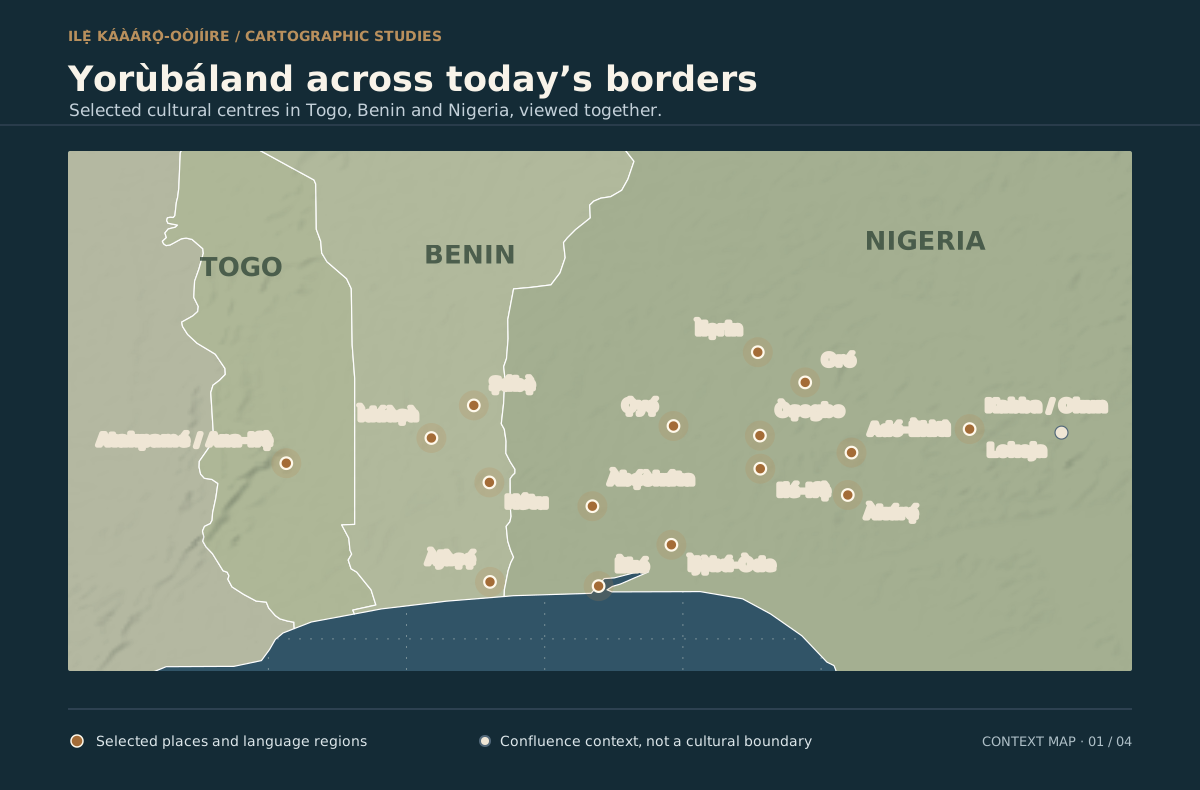
Country outlines show the current political borders. Bronze markers indicate selected places and language regions, including Oró in the family account. Download the SVG map ↗
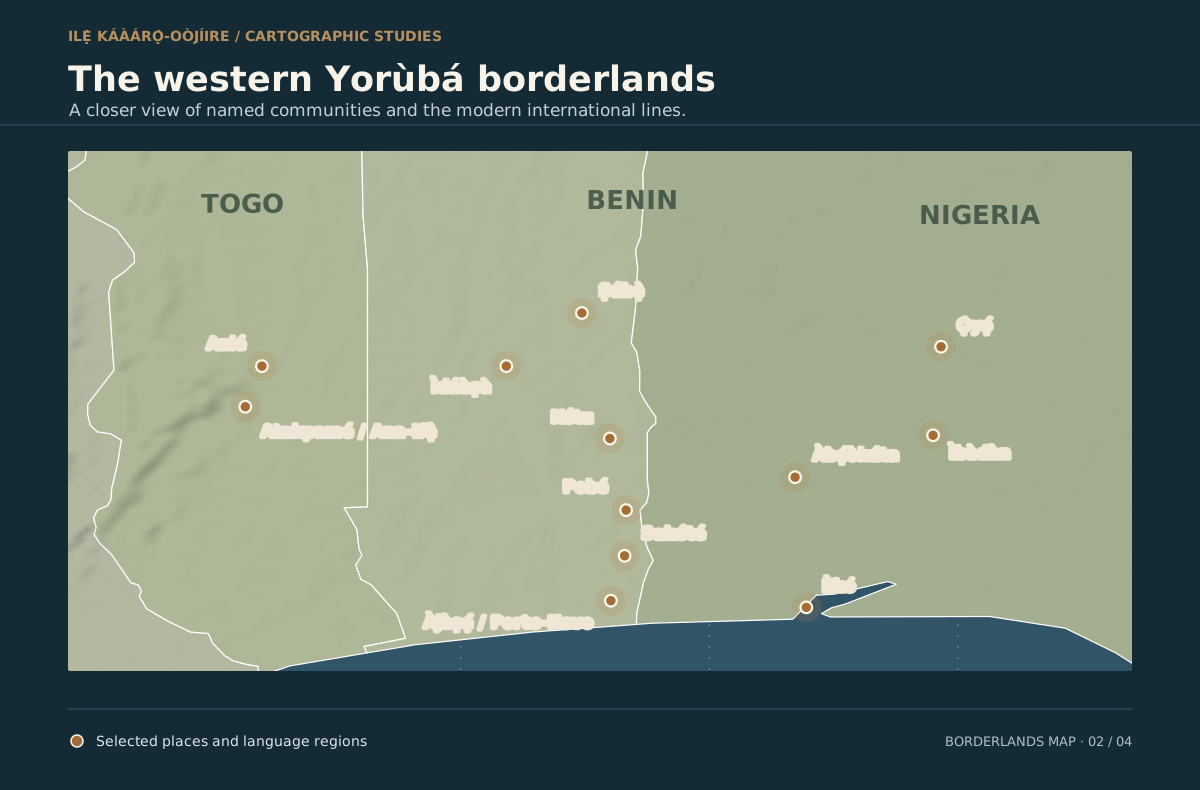
02 / THE WESTERN BORDERLANDS
Atakpamé / Ana-Ifẹ̀, Ìdáàṣà, Ṣábẹ̀, Kétu and Àjàṣẹ́ / Porto-Novo sit in conversation with centres to the east. The labels do not assert that everyone in each town has the same language or ancestry. Download the SVG map ↗
04 / RIVERS, NEIGHBOURS, CONNECTIONS
Odò Ọya (“River Niger”) and the Benue frame the northeastern confluence. Borgu, Nupe, Dahomey and Igbo societies name neighbouring historical worlds, not fixed state borders. Benin City sits within an interconnected Ifẹ̀-facing world, while its Edo-speaking kingdom developed its own political and cultural history. Violet marks distinguish a dynastic tradition from a schematic cultural separation. Download the SVG map ↗
WHY THESE MAPS BEGIN WITH PLACE
Names remember more than borders.
I foreground the names and connections people carried before the present administrative map. Colonial boundary-making divided some related communities, while local identity, language and exchange continued across those lines. The 1914 amalgamation recorded by The National Archives ↗ belongs to that later political history; it did not establish the older Yorùbá towns or their ways of life. The region’s earlier archaeological horizon is a subject for careful study, not proof that every community used a single collective name throughout antiquity. Read the editorial position ↗
THE HISTORICAL LINE
Partition followed earlier connections.
Historical work describes a Yorùbá cultural area extending through southern and central Benin toward the Ifẹ̀ and Atakpamé region of central Togo. The geographical account in The Yoruba from Prehistory to the Present ↗ notes that an Anglo-French line divided western Yorùbá communities in 1889. The colonial partition belongs to the wider late nineteenth-century process associated with the Berlin Conference of 1884–85, but a conference date is not the date every boundary was drawn.
The selected centres show Yorùbá urbanism and regional variety: Ọ̀yọ́, Ìjẹ̀bú, Èkìtì and Oǹdó, with the Ìgbómìnà and Okun communities toward the Niger–Benue confluence. The geographical study ↗ places Okun in the northeastern Yorùbá area. Excavations at Ife-Ijumu / Ìtáákpá ↗ show early occupation; competing origin accounts remain research questions. Lokoja is a multiethnic confluence town and Ajaokuta is shown as neighbouring context, so the maps do not colour either as entirely Yorùbá.
Odò Ọya is a Yorùbá name for the River Niger in the scholarship on Borgu and Bààtonu–Yorùbá connections ↗. The river and the Benue meet near Lokoja. Borgu, Nupe and the historic Kingdom of Dahomey (centred in what is now Benin) belonged to changing networks of exchange and rivalry. “Igbo societies” recognises neighbouring peoples without collapsing them into one precolonial kingdom.
Benin: connected and distinct.
The Kingdom of Benin around Benin City belongs in this view of interlocking West African histories. Its court tradition links a new dynasty to Ilé-Ifẹ̀ and Ọ̀rànmíyàn around the thirteenth to fourteenth centuries. Yet the Metropolitan Museum of Art’s account ↗ describes its Edo-speaking founders and the kingdom’s separate political and artistic development. The map’s dotted link represents that dynastic tradition; the short dashed divider is an interpretive cue between core Yorùbá centres and the Edo-speaking kingdom, not a surveyed frontier. Bronze dashes suggest western and northern contact zones with Dahomey and Borgu; none of the dashed marks is a precise precolonial boundary. This reading neither erases kinship nor absorbs Edo identity.
What is drawn, and what is inferred.
The country coastlines and borders come from Natural Earth’s public-domain 1:50m country data ↗; mapped waterways use its 1:10m rivers data ↗. Place coordinates were checked against GeoNames (CC BY 4.0) ↗, with the Ife-Ijumu and Oró points checked against separate gazetteers. The markers are selected illustrative locations; their spellings pair Yorùbá names with widely used modern place names where helpful. The town maps do not claim an exact edge to Yorùbáland or a population count. The interactive area comparison shows explicitly labelled estimates rather than a measured percentage of land across the borders. The reference images shared for this study prompted the question, but their provenance and reuse rights were not established; these are new maps drawn from the cited geographic data and research.
For me, this is a map of questions as well as places: which names survived a border, how neighbouring peoples influenced one another, and how a family story from Oró belongs within a wider, multilingual Yorùbá world.
Enable JavaScript to choose optional feedback-based suggestions.
REGIONAL DATA / PEOPLE / ECONOMIES
Explore the states behind the map.
Population history, economic output, revenue trends, fertility, migration and legislatures: nine Nigerian states, with separate context for Benin and Togo.
Read the mapped layer, source date and geographic definition together. These visualisations are geographic explanations, not AI predictions or legal boundaries.
Follow the reasoning.
SourceCheck the cited geography or estimate
LayerChoose features and time context
CompareInspect scale, area and definitions
InterpretKeep cultural and modern boundaries distinct
Explore the building blocks.
AI Capability1
AI/Data Concepts2
Data Science Pipeline1
Responsible AI1
Visualisation2
Number of concepts in this guide, not performance or usage measures.
Explore the explanation matrix · 7 concepts
7 concepts shown
On small screens, scroll the table sideways. “Learning context” explains a related idea; it does not mean that method runs on this page. Deep learning is the standard term for “deep ML”.
Technical term
Technical description / definition
In plain English
How this page uses it
Geospatial layers and projectionVisualisation
Coordinates are transformed to a map surface; separate layers encode geographic features or interpretations.Primary reference ↗
A map combines evidence layers. Its boundary lines need a date and a meaning.
Running here Separate layers show geographic features and interpreted historical or cultural regions. The source and definition control their meaning.
Visual encodingVisualisation
Mapping values or categories to marks, position, length, colour and labels.Primary reference ↗
Make the comparison visible, with a scale and a clear label.
Running here Position, colour, area and labels make comparisons visible; changing the map view does not improve source certainty.
Rates and denominatorsAI/Data Concepts
A rate or share relates a count to a defined exposure or eligible population.Primary reference ↗
Keep the number underneath the fraction visible when comparing people or periods.
Published analysis Area or population comparisons require compatible definitions and reference dates.
Extraction, transformation and provenanceData Science Pipeline
ETL moves data from sources through defined transformations; provenance records its origin and changes.Primary reference ↗
Read it, tidy it, and keep the receipt.
Method guide Prepared geographic assets retain citations and boundaries of interpretation.
Probability and uncertaintyAI/Data Concepts
A probability quantifies an event under a model and assumptions; it is not a guarantee.Primary reference ↗
A chance, not a promise. Ask what evidence and assumptions produced it.
Responsible use Approximate cultural extents and estimates should not be read as precise surveyed borders.
Human oversight and consentResponsible AI
People retain appropriate review authority, permission controls and correction routes for data use and outputs.Primary reference ↗
Keep someone able to question, correct or stop the result.
Responsible use The map supports learning and inquiry, with source notes and correction routes.
Machine learning (ML)AI Capability
Methods that estimate patterns or parameters from examples to support inference on other inputs.Primary reference ↗
Learn a pattern from examples, then check whether it helps with new ones.
Learning context These geographic views do not infer ethnicity, ancestry or future population from a trained ML model.
No matching concepts. Choose another category or clear the search.